You are here: Home > Network List > TA - USArray Transportable Network (new EarthScope stations) Stations List
> Station 242A Grayson, LA, USA > Earthquake Result Viewer
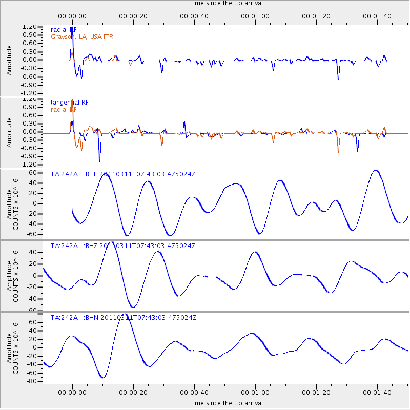
242A Grayson, LA, USA - Earthquake Result Viewer
*The percent match for this event was below the threshold and hence no stack was calculated.
| Earthquake location: |
Near East Coast Of Honshu, Japan |
| Earthquake latitude/longitude: |
37.4/141.2 |
| Earthquake time(UTC): |
2011/03/11 (070) 07:30:18 GMT |
| Earthquake Depth: |
49 km |
| Earthquake Magnitude: |
6.0 MB |
| Earthquake Catalog/Contributor: |
WHDF/NEIC |
|
| Network: |
TA USArray Transportable Network (new EarthScope stations) |
| Station: |
242A Grayson, LA, USA |
| Lat/Lon: |
32.06 N/92.15 W |
| Elevation: |
57 m |
|
| Distance: |
94.8 deg |
| Az: |
43.124 deg |
| Baz: |
320.149 deg |
| Ray Param: |
$rayparam |
*The percent match for this event was below the threshold and hence was not used in the summary stack. |
|
| Radial Match: |
51.645546 % |
| Radial Bump: |
400 |
| Transverse Match: |
75.25283 % |
| Transverse Bump: |
171 |
| SOD ConfigId: |
356183 |
| Insert Time: |
2011-08-12 10:22:51.385 +0000 |
| GWidth: |
2.5 |
| Max Bumps: |
400 |
| Tol: |
0.001 |
|
Signal To Noise
| Channel | StoN | STA | LTA |
| TA:242A: :BHZ:20110311T07:43:03.475024Z | 0.7428189 | 1.7637469E-5 | 2.3743967E-5 |
| TA:242A: :BHN:20110311T07:43:03.475024Z | 0.89464605 | 2.4350282E-5 | 2.7217784E-5 |
| TA:242A: :BHE:20110311T07:43:03.475024Z | 1.3282657 | 5.0033275E-5 | 3.7668124E-5 |
| Arrivals |
| Ps | |
| PpPs | |
| PsPs/PpSs | |


