You are here: Home > Network List > US - United States National Seismic Network Stations List
> Station WMOK Wichita Mountains, Oklahoma, USA > Earthquake Result Viewer
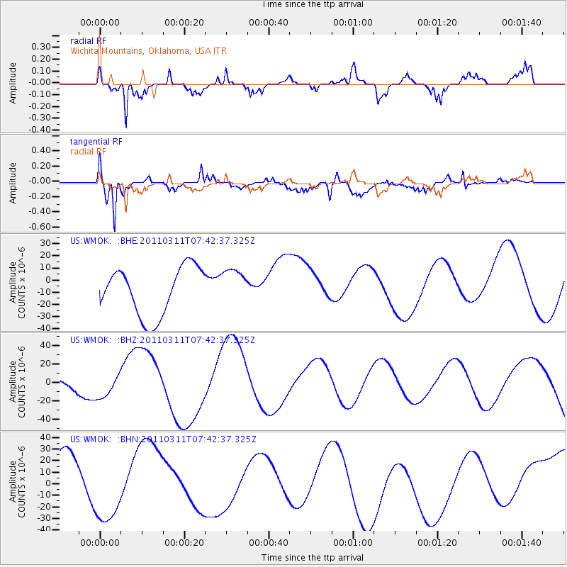
WMOK Wichita Mountains, Oklahoma, USA - Earthquake Result Viewer
*The percent match for this event was below the threshold and hence no stack was calculated.
| Earthquake location: |
Near East Coast Of Honshu, Japan |
| Earthquake latitude/longitude: |
37.4/141.2 |
| Earthquake time(UTC): |
2011/03/11 (070) 07:30:18 GMT |
| Earthquake Depth: |
49 km |
| Earthquake Magnitude: |
6.0 MB |
| Earthquake Catalog/Contributor: |
WHDF/NEIC |
|
| Network: |
US United States National Seismic Network |
| Station: |
WMOK Wichita Mountains, Oklahoma, USA |
| Lat/Lon: |
34.74 N/98.78 W |
| Elevation: |
486 m |
|
| Distance: |
89.1 deg |
| Az: |
45.49 deg |
| Baz: |
316.432 deg |
| Ray Param: |
$rayparam |
*The percent match for this event was below the threshold and hence was not used in the summary stack. |
|
| Radial Match: |
63.497467 % |
| Radial Bump: |
325 |
| Transverse Match: |
61.277313 % |
| Transverse Bump: |
400 |
| SOD ConfigId: |
356183 |
| Insert Time: |
2011-08-12 10:25:42.612 +0000 |
| GWidth: |
2.5 |
| Max Bumps: |
400 |
| Tol: |
0.001 |
|
Signal To Noise
| Channel | StoN | STA | LTA |
| US:WMOK: :BHZ:20110311T07:42:37.325Z | 1.7350628 | 1.3676534E-5 | 7.882442E-6 |
| US:WMOK: :BHN:20110311T07:42:37.325Z | 1.4959034 | 2.6038177E-5 | 1.7406324E-5 |
| US:WMOK: :BHE:20110311T07:42:37.325Z | 0.77753896 | 1.540331E-5 | 1.9810337E-5 |
| Arrivals |
| Ps | |
| PpPs | |
| PsPs/PpSs | |


