You are here: Home > Network List > TA - USArray Transportable Network (new EarthScope stations) Stations List
> Station V37A Hulbert, OK, USA > Earthquake Result Viewer
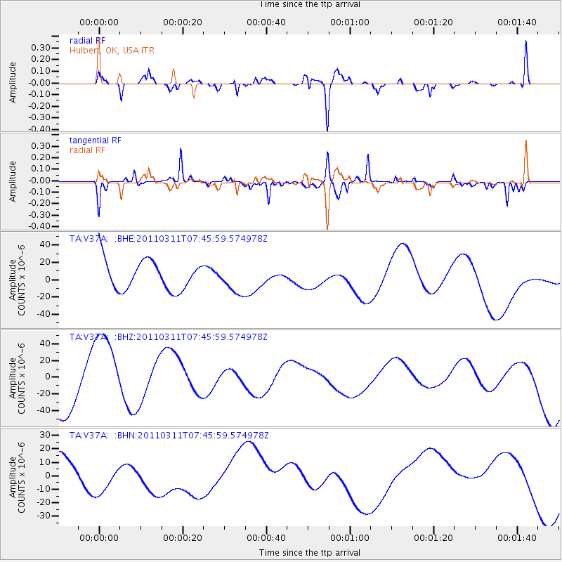
V37A Hulbert, OK, USA - Earthquake Result Viewer
*The percent match for this event was below the threshold and hence no stack was calculated.
| Earthquake location: |
Off East Coast Of Honshu, Japan |
| Earthquake latitude/longitude: |
36.3/142.7 |
| Earthquake time(UTC): |
2011/03/11 (070) 07:33:33 GMT |
| Earthquake Depth: |
35 km |
| Earthquake Magnitude: |
5.7 MB |
| Earthquake Catalog/Contributor: |
WHDF/NEIC |
|
| Network: |
TA USArray Transportable Network (new EarthScope stations) |
| Station: |
V37A Hulbert, OK, USA |
| Lat/Lon: |
35.88 N/95.14 W |
| Elevation: |
219 m |
|
| Distance: |
90.3 deg |
| Az: |
43.438 deg |
| Baz: |
316.862 deg |
| Ray Param: |
$rayparam |
*The percent match for this event was below the threshold and hence was not used in the summary stack. |
|
| Radial Match: |
67.75269 % |
| Radial Bump: |
345 |
| Transverse Match: |
46.918877 % |
| Transverse Bump: |
274 |
| SOD ConfigId: |
356183 |
| Insert Time: |
2011-08-12 12:31:35.869 +0000 |
| GWidth: |
2.5 |
| Max Bumps: |
400 |
| Tol: |
0.001 |
|
Signal To Noise
| Channel | StoN | STA | LTA |
| TA:V37A: :BHZ:20110311T07:45:59.574978Z | 1.5034136 | 5.341979E-5 | 3.5532332E-5 |
| TA:V37A: :BHN:20110311T07:45:59.574978Z | 1.7553813 | 1.3736667E-5 | 7.825461E-6 |
| TA:V37A: :BHE:20110311T07:45:59.574978Z | 0.97057456 | 1.6411483E-5 | 1.690904E-5 |
| Arrivals |
| Ps | |
| PpPs | |
| PsPs/PpSs | |


