You are here: Home > Network List > TA - USArray Transportable Network (new EarthScope stations) Stations List
> Station I32A Karley and Nick, Howard, SD, USA > Earthquake Result Viewer
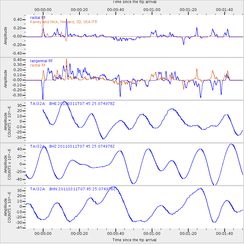
I32A Karley and Nick, Howard, SD, USA - Earthquake Result Viewer
*The percent match for this event was below the threshold and hence no stack was calculated.
| Earthquake location: |
Off East Coast Of Honshu, Japan |
| Earthquake latitude/longitude: |
36.3/142.7 |
| Earthquake time(UTC): |
2011/03/11 (070) 07:33:33 GMT |
| Earthquake Depth: |
35 km |
| Earthquake Magnitude: |
5.7 MB |
| Earthquake Catalog/Contributor: |
WHDF/NEIC |
|
| Network: |
TA USArray Transportable Network (new EarthScope stations) |
| Station: |
I32A Karley and Nick, Howard, SD, USA |
| Lat/Lon: |
44.03 N/97.46 W |
| Elevation: |
493 m |
|
| Distance: |
83.2 deg |
| Az: |
39.069 deg |
| Baz: |
315.122 deg |
| Ray Param: |
$rayparam |
*The percent match for this event was below the threshold and hence was not used in the summary stack. |
|
| Radial Match: |
65.222855 % |
| Radial Bump: |
400 |
| Transverse Match: |
55.681004 % |
| Transverse Bump: |
400 |
| SOD ConfigId: |
356183 |
| Insert Time: |
2011-08-12 12:32:49.688 +0000 |
| GWidth: |
2.5 |
| Max Bumps: |
400 |
| Tol: |
0.001 |
|
Signal To Noise
| Channel | StoN | STA | LTA |
| TA:I32A: :BHZ:20110311T07:45:25.074978Z | 1.8482625 | 3.839932E-5 | 2.0775902E-5 |
| TA:I32A: :BHN:20110311T07:45:25.074978Z | 1.9299502 | 3.4288514E-5 | 1.7766526E-5 |
| TA:I32A: :BHE:20110311T07:45:25.074978Z | 2.0943563 | 3.1978845E-5 | 1.5269055E-5 |
| Arrivals |
| Ps | |
| PpPs | |
| PsPs/PpSs | |


