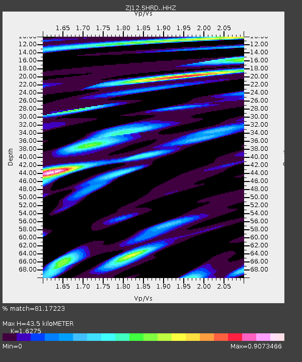
SHRD Lister Nunataks, Antarctica - Earthquake Result Viewer

Earthquake location: South Sandwich Islands Region
Earthquake latitude/longitude: -56.8/-27.3
Earthquake time(UTC): 2014/02/01 (032) 03:58:43 GMT
Earthquake Depth: 130 km
Earthquake Magnitude: 6.1 MWW, 6.1 MWC, 6.1 MWB, 6.2 MWC
Earthquake Catalog/Contributor: NEIC PDE/NEIC COMCAT
Network: ZJ Transantarctic Mountains Northern Network
Station: SHRD Lister Nunataks, Antarctica
Lat/Lon: 73.40 S/160.50 E
Elevation: 2457 m
Distance: 49.9 deg
Az: 182.936 deg
Baz: 174.379 deg
Ray Param: 0.067929395
Estimated Moho Depth: 43.5 km
Estimated Crust Vp/Vs: 1.63
Assumed Crust Vp: 6.264 km/s
Estimated Crust Vs: 3.849 km/s
Estimated Crust Poisson's Ratio: 0.20
Radial Match: 81.17223 %
Radial Bump: 400
Transverse Match: 68.79979 %
Transverse Bump: 400
SOD ConfigId: 3390531
Insert Time: 2019-04-10 04:31:09.279 +0000
GWidth: 2.5
Max Bumps: 400
Tol: 0.001

Signal To Noise

ChannelStoNSTALTA
ZJ:SHRD: :HHZ:20140201T04:06:53.019999Z13.6131563.867605E-62.8410787E-7
ZJ:SHRD: :HHN:20140201T04:06:53.019999Z7.74566132.3147604E-62.9884606E-7
ZJ:SHRD: :HHE:20140201T04:06:53.019999Z3.80042086.967032E-71.8332264E-7
Arrivals
Ps4.6 SECOND
PpPs17 SECOND
PsPs/PpSs22 SECOND