You are here: Home > Network List > TA - USArray Transportable Network (new EarthScope stations) Stations List
> Station E31A Nome, ND, USA > Earthquake Result Viewer
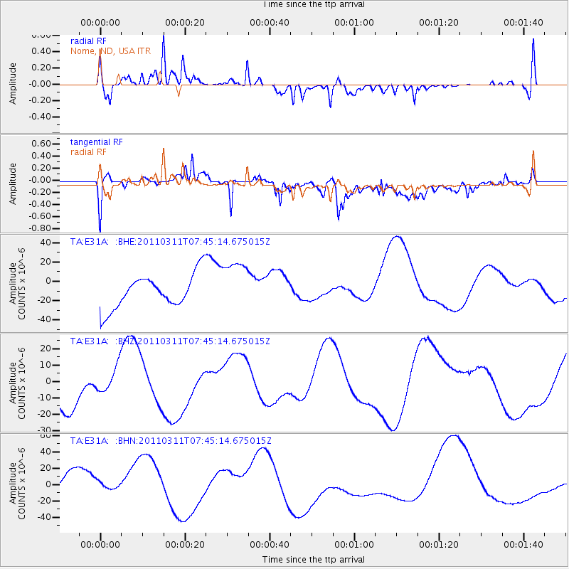
E31A Nome, ND, USA - Earthquake Result Viewer
*The percent match for this event was below the threshold and hence no stack was calculated.
| Earthquake location: |
Off East Coast Of Honshu, Japan |
| Earthquake latitude/longitude: |
36.3/142.7 |
| Earthquake time(UTC): |
2011/03/11 (070) 07:33:33 GMT |
| Earthquake Depth: |
35 km |
| Earthquake Magnitude: |
5.7 MB |
| Earthquake Catalog/Contributor: |
WHDF/NEIC |
|
| Network: |
TA USArray Transportable Network (new EarthScope stations) |
| Station: |
E31A Nome, ND, USA |
| Lat/Lon: |
46.56 N/97.89 W |
| Elevation: |
427 m |
|
| Distance: |
81.2 deg |
| Az: |
37.471 deg |
| Baz: |
314.604 deg |
| Ray Param: |
$rayparam |
*The percent match for this event was below the threshold and hence was not used in the summary stack. |
|
| Radial Match: |
65.99063 % |
| Radial Bump: |
400 |
| Transverse Match: |
58.33711 % |
| Transverse Bump: |
400 |
| SOD ConfigId: |
356183 |
| Insert Time: |
2011-08-12 12:35:28.403 +0000 |
| GWidth: |
2.5 |
| Max Bumps: |
400 |
| Tol: |
0.001 |
|
Signal To Noise
| Channel | StoN | STA | LTA |
| TA:E31A: :BHZ:20110311T07:45:14.675015Z | 0.5588773 | 8.457938E-6 | 1.5133802E-5 |
| TA:E31A: :BHN:20110311T07:45:14.675015Z | 0.64328665 | 1.6420194E-5 | 2.5525469E-5 |
| TA:E31A: :BHE:20110311T07:45:14.675015Z | 1.549654 | 2.7044049E-5 | 1.7451668E-5 |
| Arrivals |
| Ps | |
| PpPs | |
| PsPs/PpSs | |


