You are here: Home > Network List > US - United States National Seismic Network Stations List
> Station AMTX Amarillo, Texas, USA > Earthquake Result Viewer
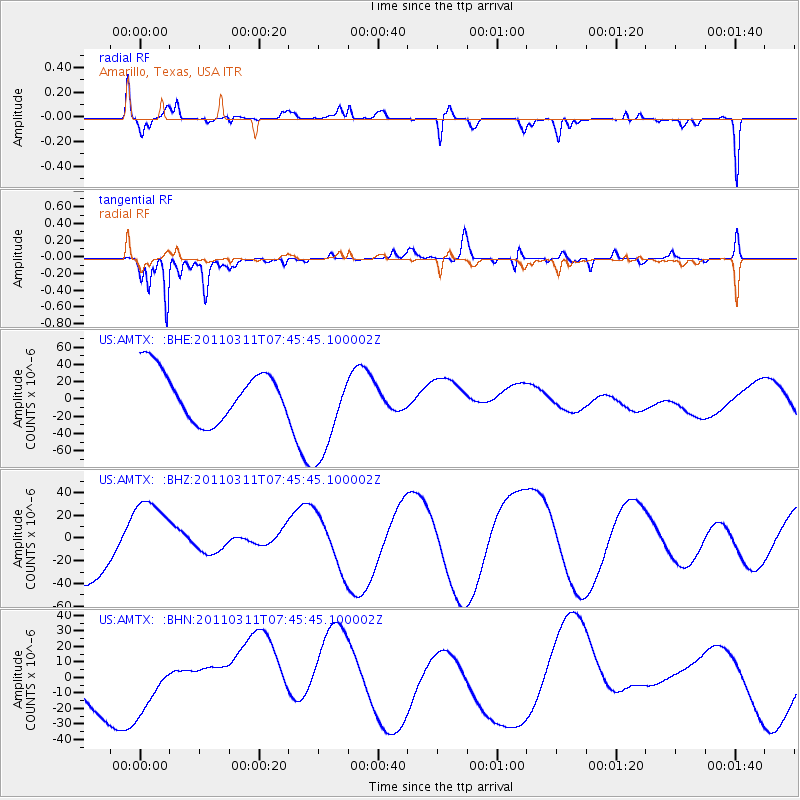
AMTX Amarillo, Texas, USA - Earthquake Result Viewer
*The percent match for this event was below the threshold and hence no stack was calculated.
| Earthquake location: |
Off East Coast Of Honshu, Japan |
| Earthquake latitude/longitude: |
36.3/142.7 |
| Earthquake time(UTC): |
2011/03/11 (070) 07:33:33 GMT |
| Earthquake Depth: |
35 km |
| Earthquake Magnitude: |
5.7 MB |
| Earthquake Catalog/Contributor: |
WHDF/NEIC |
|
| Network: |
US United States National Seismic Network |
| Station: |
AMTX Amarillo, Texas, USA |
| Lat/Lon: |
34.53 N/101.41 W |
| Elevation: |
1010 m |
|
| Distance: |
87.6 deg |
| Az: |
48.025 deg |
| Baz: |
313.347 deg |
| Ray Param: |
$rayparam |
*The percent match for this event was below the threshold and hence was not used in the summary stack. |
|
| Radial Match: |
42.883976 % |
| Radial Bump: |
400 |
| Transverse Match: |
60.27897 % |
| Transverse Bump: |
282 |
| SOD ConfigId: |
356183 |
| Insert Time: |
2011-08-12 12:49:34.746 +0000 |
| GWidth: |
2.5 |
| Max Bumps: |
400 |
| Tol: |
0.001 |
|
Signal To Noise
| Channel | StoN | STA | LTA |
| US:AMTX: :BHZ:20110311T07:45:45.100002Z | 1.6670874 | 3.426317E-5 | 2.0552712E-5 |
| US:AMTX: :BHN:20110311T07:45:45.100002Z | 1.335766 | 1.4929618E-5 | 1.1176822E-5 |
| US:AMTX: :BHE:20110311T07:45:45.100002Z | 1.2552953 | 3.4342636E-5 | 2.7358212E-5 |
| Arrivals |
| Ps | |
| PpPs | |
| PsPs/PpSs | |


