You are here: Home > Network List > CI - Caltech Regional Seismic Network Stations List
> Station TIN Tinemaha, Big Pine, CA, USA > Earthquake Result Viewer
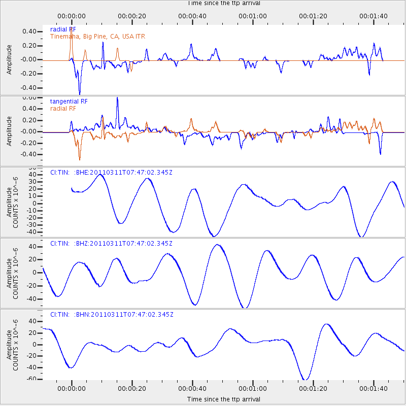
TIN Tinemaha, Big Pine, CA, USA - Earthquake Result Viewer
*The percent match for this event was below the threshold and hence no stack was calculated.
| Earthquake location: |
Off East Coast Of Honshu, Japan |
| Earthquake latitude/longitude: |
36.9/142.3 |
| Earthquake time(UTC): |
2011/03/11 (070) 07:35:52 GMT |
| Earthquake Depth: |
22 km |
| Earthquake Magnitude: |
5.7 MB |
| Earthquake Catalog/Contributor: |
WHDF/NEIC |
|
| Network: |
CI Caltech Regional Seismic Network |
| Station: |
TIN Tinemaha, Big Pine, CA, USA |
| Lat/Lon: |
37.05 N/118.23 W |
| Elevation: |
1197 m |
|
| Distance: |
75.3 deg |
| Az: |
54.668 deg |
| Baz: |
305.214 deg |
| Ray Param: |
$rayparam |
*The percent match for this event was below the threshold and hence was not used in the summary stack. |
|
| Radial Match: |
70.87533 % |
| Radial Bump: |
400 |
| Transverse Match: |
58.00095 % |
| Transverse Bump: |
400 |
| SOD ConfigId: |
356183 |
| Insert Time: |
2011-08-12 13:11:07.511 +0000 |
| GWidth: |
2.5 |
| Max Bumps: |
400 |
| Tol: |
0.001 |
|
Signal To Noise
| Channel | StoN | STA | LTA |
| CI:TIN: :BHZ:20110311T07:47:02.345Z | 0.53620994 | 1.3990192E-5 | 2.6090887E-5 |
| CI:TIN: :BHN:20110311T07:47:02.345Z | 4.9563413 | 4.1862764E-5 | 8.446304E-6 |
| CI:TIN: :BHE:20110311T07:47:02.345Z | 2.0621698 | 4.1832314E-5 | 2.0285583E-5 |
| Arrivals |
| Ps | |
| PpPs | |
| PsPs/PpSs | |


