You are here: Home > Network List > TA - USArray Transportable Network (new EarthScope stations) Stations List
> Station U31A Nine Bar Ranch, Gage, OK, USA > Earthquake Result Viewer
U31A Nine Bar Ranch, Gage, OK, USA - Earthquake Result Viewer
| Earthquake location: |
Off East Coast Of Honshu, Japan |
| Earthquake latitude/longitude: |
36.9/142.3 |
| Earthquake time(UTC): |
2011/03/11 (070) 07:35:52 GMT |
| Earthquake Depth: |
22 km |
| Earthquake Magnitude: |
5.7 MB |
| Earthquake Catalog/Contributor: |
WHDF/NEIC |
|
| Network: |
TA USArray Transportable Network (new EarthScope stations) |
| Station: |
U31A Nine Bar Ranch, Gage, OK, USA |
| Lat/Lon: |
36.37 N/99.85 W |
| Elevation: |
725 m |
|
| Distance: |
87.1 deg |
| Az: |
45.613 deg |
| Baz: |
314.816 deg |
| Ray Param: |
0.04357859 |
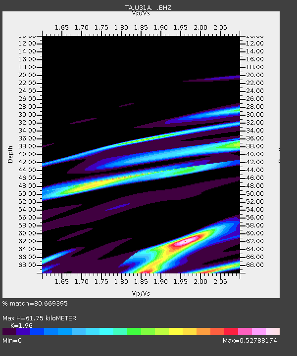
| Estimated Moho Depth: |
61.75 km |
| Estimated Crust Vp/Vs: |
1.96 |
| Assumed Crust Vp: |
6.426 km/s |
| Estimated Crust Vs: |
3.279 km/s |
| Estimated Crust Poisson's Ratio: |
0.32 |
|
| Radial Match: |
80.669395 % |
| Radial Bump: |
373 |
| Transverse Match: |
52.48764 % |
| Transverse Bump: |
344 |
| SOD ConfigId: |
356183 |
| Insert Time: |
2011-08-12 13:41:29.623 +0000 |
| GWidth: |
2.5 |
| Max Bumps: |
400 |
| Tol: |
0.001 |
|
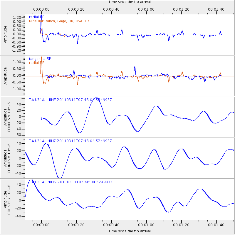
Signal To Noise
| Channel | StoN | STA | LTA |
| TA:U31A: :BHZ:20110311T07:48:04.524993Z | 1.4321092 | 3.1124266E-5 | 2.1733164E-5 |
| TA:U31A: :BHN:20110311T07:48:04.524993Z | 0.46833077 | 1.532751E-5 | 3.272796E-5 |
| TA:U31A: :BHE:20110311T07:48:04.524993Z | 3.5649204 | 6.91929E-5 | 1.9409383E-5 |
| Arrivals |
| Ps | 9.4 SECOND |
| PpPs | 28 SECOND |
| PsPs/PpSs | 37 SECOND |


