You are here: Home > Network List > TA - USArray Transportable Network (new EarthScope stations) Stations List
> Station W56A Indian Trail, NC, USA > Earthquake Result Viewer
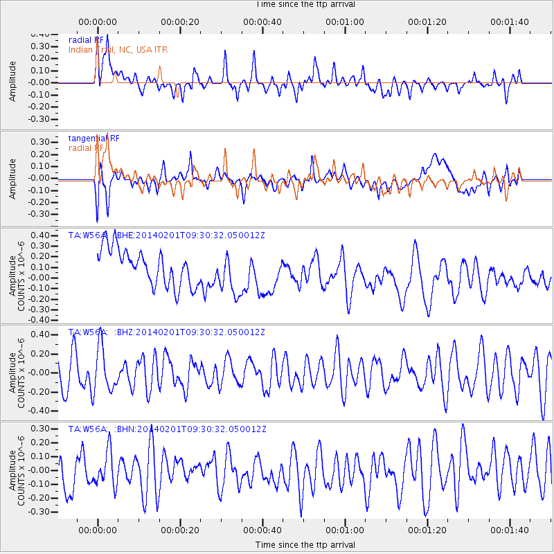
W56A Indian Trail, NC, USA - Earthquake Result Viewer
*The percent match for this event was below the threshold and hence no stack was calculated.
| Earthquake location: |
Southern East Pacific Rise |
| Earthquake latitude/longitude: |
-55.1/-126.6 |
| Earthquake time(UTC): |
2014/02/01 (032) 09:17:26 GMT |
| Earthquake Depth: |
10 km |
| Earthquake Magnitude: |
5.2 MW |
| Earthquake Catalog/Contributor: |
ISC/ISC |
|
| Network: |
TA USArray Transportable Network (new EarthScope stations) |
| Station: |
W56A Indian Trail, NC, USA |
| Lat/Lon: |
35.13 N/80.58 W |
| Elevation: |
177 m |
|
| Distance: |
98.2 deg |
| Az: |
36.57 deg |
| Baz: |
204.681 deg |
| Ray Param: |
$rayparam |
*The percent match for this event was below the threshold and hence was not used in the summary stack. |
|
| Radial Match: |
48.258316 % |
| Radial Bump: |
400 |
| Transverse Match: |
37.425823 % |
| Transverse Bump: |
400 |
| SOD ConfigId: |
3390531 |
| Insert Time: |
2019-04-10 04:34:18.643 +0000 |
| GWidth: |
2.5 |
| Max Bumps: |
400 |
| Tol: |
0.001 |
|
Signal To Noise
| Channel | StoN | STA | LTA |
| TA:W56A: :BHZ:20140201T09:30:32.050012Z | 1.3259274 | 2.3354441E-7 | 1.7613665E-7 |
| TA:W56A: :BHN:20140201T09:30:32.050012Z | 0.7528592 | 1.2744361E-7 | 1.6927949E-7 |
| TA:W56A: :BHE:20140201T09:30:32.050012Z | 1.2005807 | 2.0498192E-7 | 1.7073565E-7 |
| Arrivals |
| Ps | |
| PpPs | |
| PsPs/PpSs | |


