You are here: Home > Network List > TA - USArray Transportable Network (new EarthScope stations) Stations List
> Station 336A Riesel, TX, USA > Earthquake Result Viewer
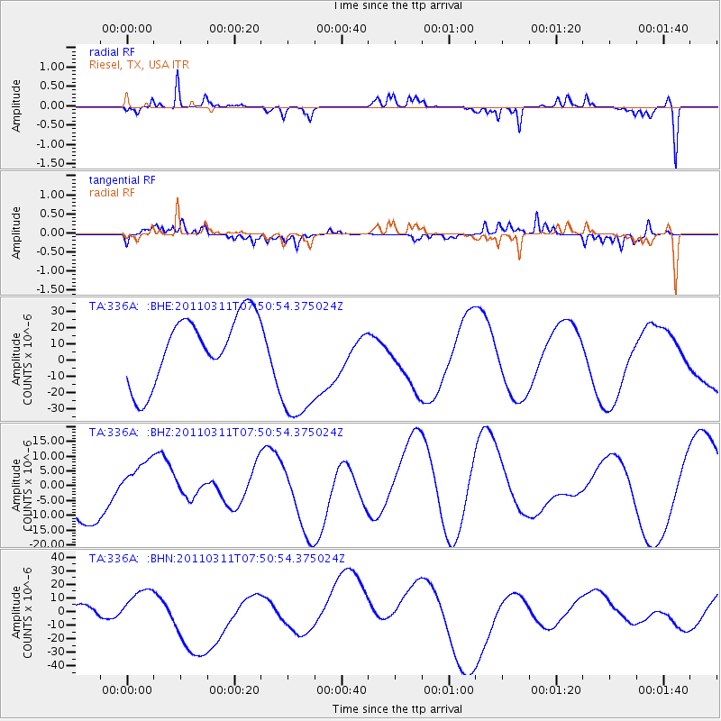
336A Riesel, TX, USA - Earthquake Result Viewer
*The percent match for this event was below the threshold and hence no stack was calculated.
| Earthquake location: |
Near East Coast Of Honshu, Japan |
| Earthquake latitude/longitude: |
39.2/142.8 |
| Earthquake time(UTC): |
2011/03/11 (070) 07:38:27 GMT |
| Earthquake Depth: |
38 km |
| Earthquake Magnitude: |
5.8 MB |
| Earthquake Catalog/Contributor: |
WHDF/NEIC |
|
| Network: |
TA USArray Transportable Network (new EarthScope stations) |
| Station: |
336A Riesel, TX, USA |
| Lat/Lon: |
31.39 N/96.84 W |
| Elevation: |
140 m |
|
| Distance: |
90.6 deg |
| Az: |
47.557 deg |
| Baz: |
317.899 deg |
| Ray Param: |
$rayparam |
*The percent match for this event was below the threshold and hence was not used in the summary stack. |
|
| Radial Match: |
47.42491 % |
| Radial Bump: |
281 |
| Transverse Match: |
38.098515 % |
| Transverse Bump: |
216 |
| SOD ConfigId: |
356183 |
| Insert Time: |
2011-08-12 16:05:01.983 +0000 |
| GWidth: |
2.5 |
| Max Bumps: |
400 |
| Tol: |
0.001 |
|
Signal To Noise
| Channel | StoN | STA | LTA |
| TA:336A: :BHZ:20110311T07:50:54.375024Z | 1.098168 | 9.0638005E-6 | 8.253564E-6 |
| TA:336A: :BHN:20110311T07:50:54.375024Z | 4.0845966 | 1.2301675E-5 | 3.0117233E-6 |
| TA:336A: :BHE:20110311T07:50:54.375024Z | 1.9247582 | 3.951456E-5 | 2.0529624E-5 |
| Arrivals |
| Ps | |
| PpPs | |
| PsPs/PpSs | |


