You are here: Home > Network List > CN - Canadian National Seismograph Network Stations List
> Station INK INUVIK, NT > Earthquake Result Viewer
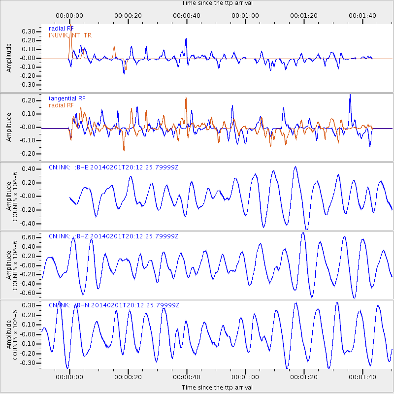
INK INUVIK, NT - Earthquake Result Viewer
*The percent match for this event was below the threshold and hence no stack was calculated.
| Earthquake location: |
Santa Cruz Islands |
| Earthquake latitude/longitude: |
-11.5/166.3 |
| Earthquake time(UTC): |
2014/02/01 (032) 20:00:01 GMT |
| Earthquake Depth: |
46 km |
| Earthquake Magnitude: |
5.7 MWW, 5.7 MWB, 5.8 MWC |
| Earthquake Catalog/Contributor: |
NEIC PDE/NEIC COMCAT |
|
| Network: |
CN Canadian National Seismograph Network |
| Station: |
INK INUVIK, NT |
| Lat/Lon: |
68.31 N/133.53 W |
| Elevation: |
44 m |
|
| Distance: |
90.1 deg |
| Az: |
18.821 deg |
| Baz: |
238.28 deg |
| Ray Param: |
$rayparam |
*The percent match for this event was below the threshold and hence was not used in the summary stack. |
|
| Radial Match: |
41.36903 % |
| Radial Bump: |
400 |
| Transverse Match: |
63.40385 % |
| Transverse Bump: |
400 |
| SOD ConfigId: |
3390531 |
| Insert Time: |
2019-04-10 04:37:17.474 +0000 |
| GWidth: |
2.5 |
| Max Bumps: |
400 |
| Tol: |
0.001 |
|
Signal To Noise
| Channel | StoN | STA | LTA |
| CN:INK: :BHZ:20140201T20:12:25.79999Z | 2.3713112 | 4.184541E-7 | 1.7646528E-7 |
| CN:INK: :BHN:20140201T20:12:25.79999Z | 1.3971618 | 2.2794863E-7 | 1.631512E-7 |
| CN:INK: :BHE:20140201T20:12:25.79999Z | 0.99896485 | 1.2970449E-7 | 1.298389E-7 |
| Arrivals |
| Ps | |
| PpPs | |
| PsPs/PpSs | |


