You are here: Home > Network List > TA - USArray Transportable Network (new EarthScope stations) Stations List
> Station A36M Sachs Harbour, NT, CAN > Earthquake Result Viewer
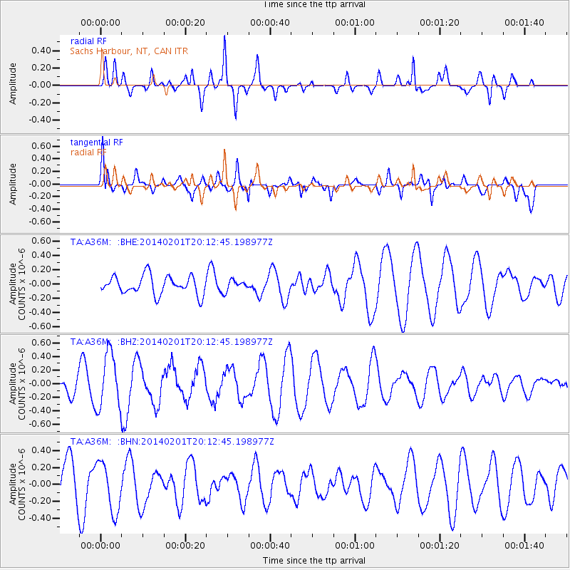
A36M Sachs Harbour, NT, CAN - Earthquake Result Viewer
*The percent match for this event was below the threshold and hence no stack was calculated.
| Earthquake location: |
Santa Cruz Islands |
| Earthquake latitude/longitude: |
-11.5/166.3 |
| Earthquake time(UTC): |
2014/02/01 (032) 20:00:01 GMT |
| Earthquake Depth: |
46 km |
| Earthquake Magnitude: |
5.7 MWW, 5.7 MWB, 5.8 MWC |
| Earthquake Catalog/Contributor: |
NEIC PDE/NEIC COMCAT |
|
| Network: |
TA USArray Transportable Network (new EarthScope stations) |
| Station: |
A36M Sachs Harbour, NT, CAN |
| Lat/Lon: |
71.99 N/125.25 W |
| Elevation: |
32 m |
|
| Distance: |
94.3 deg |
| Az: |
16.873 deg |
| Baz: |
246.142 deg |
| Ray Param: |
$rayparam |
*The percent match for this event was below the threshold and hence was not used in the summary stack. |
|
| Radial Match: |
70.527596 % |
| Radial Bump: |
400 |
| Transverse Match: |
74.79282 % |
| Transverse Bump: |
400 |
| SOD ConfigId: |
3390531 |
| Insert Time: |
2019-04-10 04:38:23.430 +0000 |
| GWidth: |
2.5 |
| Max Bumps: |
400 |
| Tol: |
0.001 |
|
Signal To Noise
| Channel | StoN | STA | LTA |
| TA:A36M: :BHZ:20140201T20:12:45.198977Z | 4.167986 | 4.0559075E-7 | 9.7310966E-8 |
| TA:A36M: :BHN:20140201T20:12:45.198977Z | 1.5120015 | 2.9535187E-7 | 1.9533833E-7 |
| TA:A36M: :BHE:20140201T20:12:45.198977Z | 0.6297393 | 8.152338E-8 | 1.2945577E-7 |
| Arrivals |
| Ps | |
| PpPs | |
| PsPs/PpSs | |


