You are here: Home > Network List > TA - USArray Transportable Network (new EarthScope stations) Stations List
> Station X36A Centrahoma, OK, USA > Earthquake Result Viewer
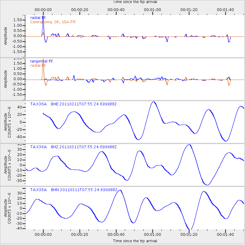
X36A Centrahoma, OK, USA - Earthquake Result Viewer
*The percent match for this event was below the threshold and hence no stack was calculated.
| Earthquake location: |
Near East Coast Of Honshu, Japan |
| Earthquake latitude/longitude: |
36.4/141.9 |
| Earthquake time(UTC): |
2011/03/11 (070) 07:42:55 GMT |
| Earthquake Depth: |
35 km |
| Earthquake Magnitude: |
5.7 MB |
| Earthquake Catalog/Contributor: |
WHDF/NEIC |
|
| Network: |
TA USArray Transportable Network (new EarthScope stations) |
| Station: |
X36A Centrahoma, OK, USA |
| Lat/Lon: |
34.57 N/96.35 W |
| Elevation: |
211 m |
|
| Distance: |
91.0 deg |
| Az: |
44.569 deg |
| Baz: |
316.679 deg |
| Ray Param: |
$rayparam |
*The percent match for this event was below the threshold and hence was not used in the summary stack. |
|
| Radial Match: |
63.868816 % |
| Radial Bump: |
351 |
| Transverse Match: |
70.348 % |
| Transverse Bump: |
352 |
| SOD ConfigId: |
356183 |
| Insert Time: |
2011-08-12 17:58:10.230 +0000 |
| GWidth: |
2.5 |
| Max Bumps: |
400 |
| Tol: |
0.001 |
|
Signal To Noise
| Channel | StoN | STA | LTA |
| TA:X36A: :BHZ:20110311T07:55:24.699988Z | 0.6353671 | 8.692634E-6 | 1.3681279E-5 |
| TA:X36A: :BHN:20110311T07:55:24.699988Z | 1.0938219 | 8.883571E-6 | 8.121589E-6 |
| TA:X36A: :BHE:20110311T07:55:24.699988Z | 1.9710983 | 2.9369494E-5 | 1.4900065E-5 |
| Arrivals |
| Ps | |
| PpPs | |
| PsPs/PpSs | |


