You are here: Home > Network List > TA - USArray Transportable Network (new EarthScope stations) Stations List
> Station B34A Aery, Baudette, MN, USA > Earthquake Result Viewer
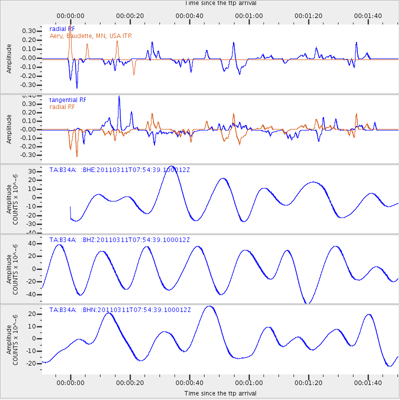
B34A Aery, Baudette, MN, USA - Earthquake Result Viewer
*The percent match for this event was below the threshold and hence no stack was calculated.
| Earthquake location: |
Near East Coast Of Honshu, Japan |
| Earthquake latitude/longitude: |
36.4/141.9 |
| Earthquake time(UTC): |
2011/03/11 (070) 07:42:55 GMT |
| Earthquake Depth: |
35 km |
| Earthquake Magnitude: |
5.7 MB |
| Earthquake Catalog/Contributor: |
WHDF/NEIC |
|
| Network: |
TA USArray Transportable Network (new EarthScope stations) |
| Station: |
B34A Aery, Baudette, MN, USA |
| Lat/Lon: |
48.49 N/94.65 W |
| Elevation: |
354 m |
|
| Distance: |
81.6 deg |
| Az: |
34.125 deg |
| Baz: |
317.134 deg |
| Ray Param: |
$rayparam |
*The percent match for this event was below the threshold and hence was not used in the summary stack. |
|
| Radial Match: |
68.33978 % |
| Radial Bump: |
317 |
| Transverse Match: |
74.70894 % |
| Transverse Bump: |
293 |
| SOD ConfigId: |
356183 |
| Insert Time: |
2011-08-12 18:05:24.989 +0000 |
| GWidth: |
2.5 |
| Max Bumps: |
400 |
| Tol: |
0.001 |
|
Signal To Noise
| Channel | StoN | STA | LTA |
| TA:B34A: :BHZ:20110311T07:54:39.100012Z | 1.3326865 | 2.8954704E-5 | 2.1726568E-5 |
| TA:B34A: :BHN:20110311T07:54:39.100012Z | 0.30731395 | 4.0156283E-6 | 1.30668595E-5 |
| TA:B34A: :BHE:20110311T07:54:39.100012Z | 3.452796 | 3.3128337E-5 | 9.594641E-6 |
| Arrivals |
| Ps | |
| PpPs | |
| PsPs/PpSs | |


