You are here: Home > Network List > TA - USArray Transportable Network (new EarthScope stations) Stations List
> Station I37A Lemond, Waseca, MN, USA > Earthquake Result Viewer
I37A Lemond, Waseca, MN, USA - Earthquake Result Viewer
| Earthquake location: |
Near East Coast Of Honshu, Japan |
| Earthquake latitude/longitude: |
36.4/141.9 |
| Earthquake time(UTC): |
2011/03/11 (070) 07:42:55 GMT |
| Earthquake Depth: |
35 km |
| Earthquake Magnitude: |
5.7 MB |
| Earthquake Catalog/Contributor: |
WHDF/NEIC |
|
| Network: |
TA USArray Transportable Network (new EarthScope stations) |
| Station: |
I37A Lemond, Waseca, MN, USA |
| Lat/Lon: |
44.01 N/93.40 W |
| Elevation: |
371 m |
|
| Distance: |
85.5 deg |
| Az: |
36.506 deg |
| Baz: |
318.301 deg |
| Ray Param: |
0.044642247 |
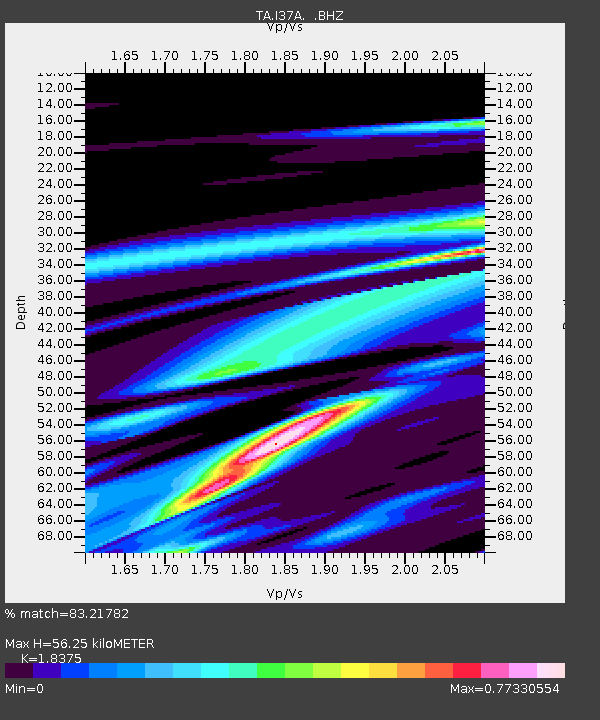
| Estimated Moho Depth: |
56.25 km |
| Estimated Crust Vp/Vs: |
1.84 |
| Assumed Crust Vp: |
6.571 km/s |
| Estimated Crust Vs: |
3.576 km/s |
| Estimated Crust Poisson's Ratio: |
0.29 |
|
| Radial Match: |
83.21782 % |
| Radial Bump: |
400 |
| Transverse Match: |
70.70356 % |
| Transverse Bump: |
209 |
| SOD ConfigId: |
356183 |
| Insert Time: |
2011-08-12 18:06:34.617 +0000 |
| GWidth: |
2.5 |
| Max Bumps: |
400 |
| Tol: |
0.001 |
|

Signal To Noise
| Channel | StoN | STA | LTA |
| TA:I37A: :BHZ:20110311T07:54:58.975012Z | 3.1902432 | 2.872789E-5 | 9.004922E-6 |
| TA:I37A: :BHN:20110311T07:54:58.975012Z | 1.364277 | 2.4637542E-5 | 1.8059045E-5 |
| TA:I37A: :BHE:20110311T07:54:58.975012Z | 0.87148374 | 1.2475885E-5 | 1.4315683E-5 |
| Arrivals |
| Ps | 7.3 SECOND |
| PpPs | 24 SECOND |
| PsPs/PpSs | 31 SECOND |


