You are here: Home > Network List > G - GEOSCOPE Stations List
> Station PPTF Pamatai - Papeete - Tahiti island - French Polynesia, France > Earthquake Result Viewer
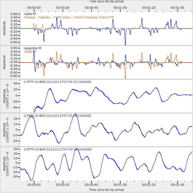
PPTF Pamatai - Papeete - Tahiti island - French Polynesia, France - Earthquake Result Viewer
*The percent match for this event was below the threshold and hence no stack was calculated.
| Earthquake location: |
Near East Coast Of Honshu, Japan |
| Earthquake latitude/longitude: |
36.2/141.8 |
| Earthquake time(UTC): |
2011/03/11 (070) 07:44:27 GMT |
| Earthquake Depth: |
14 km |
| Earthquake Magnitude: |
5.8 MB |
| Earthquake Catalog/Contributor: |
WHDF/NEIC |
|
| Network: |
G GEOSCOPE |
| Station: |
PPTF Pamatai - Papeete - Tahiti island - French Polynesia, France |
| Lat/Lon: |
17.59 S/149.57 W |
| Elevation: |
705 m |
|
| Distance: |
84.0 deg |
| Az: |
116.734 deg |
| Baz: |
310.765 deg |
| Ray Param: |
$rayparam |
*The percent match for this event was below the threshold and hence was not used in the summary stack. |
|
| Radial Match: |
65.42804 % |
| Radial Bump: |
272 |
| Transverse Match: |
62.16394 % |
| Transverse Bump: |
328 |
| SOD ConfigId: |
356183 |
| Insert Time: |
2011-08-12 18:51:41.836 +0000 |
| GWidth: |
2.5 |
| Max Bumps: |
400 |
| Tol: |
0.001 |
|
Signal To Noise
| Channel | StoN | STA | LTA |
| G:PPTF:00:BHZ:20110311T07:56:26.299998Z | 0.9945466 | 1.3261257E-5 | 1.3333972E-5 |
| G:PPTF:00:BHN:20110311T07:56:26.299998Z | 0.98828024 | 2.1981146E-5 | 2.2241817E-5 |
| G:PPTF:00:BHE:20110311T07:56:26.299998Z | 1.6065154 | 3.1903845E-5 | 1.9859035E-5 |
| Arrivals |
| Ps | |
| PpPs | |
| PsPs/PpSs | |


