You are here: Home > Network List > TA - USArray Transportable Network (new EarthScope stations) Stations List
> Station U36A Oologah, OK, USA > Earthquake Result Viewer
U36A Oologah, OK, USA - Earthquake Result Viewer
| Earthquake location: |
Near East Coast Of Honshu, Japan |
| Earthquake latitude/longitude: |
36.2/141.8 |
| Earthquake time(UTC): |
2011/03/11 (070) 07:44:27 GMT |
| Earthquake Depth: |
14 km |
| Earthquake Magnitude: |
5.8 MB |
| Earthquake Catalog/Contributor: |
WHDF/NEIC |
|
| Network: |
TA USArray Transportable Network (new EarthScope stations) |
| Station: |
U36A Oologah, OK, USA |
| Lat/Lon: |
36.39 N/95.73 W |
| Elevation: |
187 m |
|
| Distance: |
90.2 deg |
| Az: |
42.91 deg |
| Baz: |
316.956 deg |
| Ray Param: |
0.04169207 |
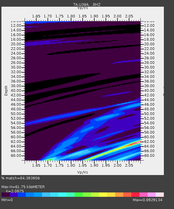
| Estimated Moho Depth: |
61.75 km |
| Estimated Crust Vp/Vs: |
2.10 |
| Assumed Crust Vp: |
6.53 km/s |
| Estimated Crust Vs: |
3.113 km/s |
| Estimated Crust Poisson's Ratio: |
0.35 |
|
| Radial Match: |
84.393906 % |
| Radial Bump: |
289 |
| Transverse Match: |
58.05545 % |
| Transverse Bump: |
241 |
| SOD ConfigId: |
356183 |
| Insert Time: |
2011-08-12 19:39:05.422 +0000 |
| GWidth: |
2.5 |
| Max Bumps: |
400 |
| Tol: |
0.001 |
|
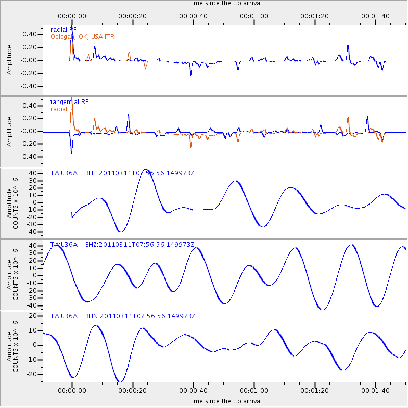
Signal To Noise
| Channel | StoN | STA | LTA |
| TA:U36A: :BHZ:20110311T07:56:56.149973Z | 1.069819 | 2.0101208E-5 | 1.8789353E-5 |
| TA:U36A: :BHN:20110311T07:56:56.149973Z | 8.373765 | 2.1113663E-5 | 2.5214063E-6 |
| TA:U36A: :BHE:20110311T07:56:56.149973Z | 0.2955494 | 6.6009757E-6 | 2.2334594E-5 |
| Arrivals |
| Ps | 11 SECOND |
| PpPs | 29 SECOND |
| PsPs/PpSs | 39 SECOND |


