You are here: Home > Network List > TA - USArray Transportable Network (new EarthScope stations) Stations List
> Station L04D Klamath Falls, OR, USA > Earthquake Result Viewer
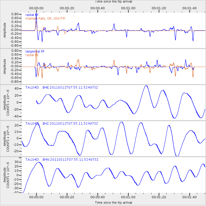
L04D Klamath Falls, OR, USA - Earthquake Result Viewer
*The percent match for this event was below the threshold and hence no stack was calculated.
| Earthquake location: |
Near East Coast Of Honshu, Japan |
| Earthquake latitude/longitude: |
36.2/141.8 |
| Earthquake time(UTC): |
2011/03/11 (070) 07:44:27 GMT |
| Earthquake Depth: |
14 km |
| Earthquake Magnitude: |
5.8 MB |
| Earthquake Catalog/Contributor: |
WHDF/NEIC |
|
| Network: |
TA USArray Transportable Network (new EarthScope stations) |
| Station: |
L04D Klamath Falls, OR, USA |
| Lat/Lon: |
42.22 N/122.30 W |
| Elevation: |
1437 m |
|
| Distance: |
70.6 deg |
| Az: |
51.57 deg |
| Baz: |
301.457 deg |
| Ray Param: |
$rayparam |
*The percent match for this event was below the threshold and hence was not used in the summary stack. |
|
| Radial Match: |
59.74369 % |
| Radial Bump: |
356 |
| Transverse Match: |
47.40179 % |
| Transverse Bump: |
244 |
| SOD ConfigId: |
356183 |
| Insert Time: |
2011-08-12 19:40:10.472 +0000 |
| GWidth: |
2.5 |
| Max Bumps: |
400 |
| Tol: |
0.001 |
|
Signal To Noise
| Channel | StoN | STA | LTA |
| TA:L04D: :BHZ:20110311T07:55:11.524973Z | 2.2290137 | 2.4866622E-5 | 1.1155887E-5 |
| TA:L04D: :BHN:20110311T07:55:11.524973Z | 1.2111816 | 2.5810226E-5 | 2.1309954E-5 |
| TA:L04D: :BHE:20110311T07:55:11.524973Z | 0.7631642 | 1.167463E-5 | 1.5297663E-5 |
| Arrivals |
| Ps | |
| PpPs | |
| PsPs/PpSs | |


