You are here: Home > Network List > AZ - ANZA Regional Network Stations List
> Station LVA2 AZ.LVA2 > Earthquake Result Viewer
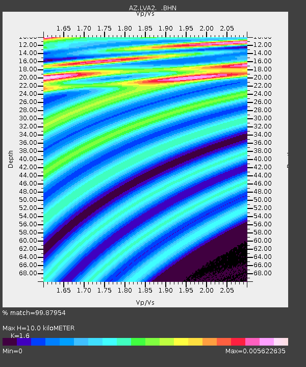
LVA2 AZ.LVA2 - Earthquake Result Viewer
| Earthquake location: |
Mongolia |
| Earthquake latitude/longitude: |
44.5/102.4 |
| Earthquake time(UTC): |
2006/04/30 (120) 00:43:10 GMT |
| Earthquake Depth: |
10 km |
| Earthquake Magnitude: |
5.6 MB, 5.7 MS, 5.7 MW, 5.7 MW |
| Earthquake Catalog/Contributor: |
WHDF/NEIC |
|
| Network: |
AZ ANZA Regional Network |
| Station: |
LVA2 AZ.LVA2 |
| Lat/Lon: |
33.35 N/116.56 W |
| Elevation: |
1435 m |
|
| Distance: |
94.8 deg |
| Az: |
31.869 deg |
| Baz: |
333.168 deg |
| Ray Param: |
0.040953778 |
| Estimated Moho Depth: |
10.0 km |
| Estimated Crust Vp/Vs: |
1.60 |
| Assumed Crust Vp: |
6.264 km/s |
| Estimated Crust Vs: |
3.915 km/s |
| Estimated Crust Poisson's Ratio: |
0.18 |
|
| Radial Match: |
99.87954 % |
| Radial Bump: |
19 |
| Transverse Match: |
87.504875 % |
| Transverse Bump: |
362 |
| SOD ConfigId: |
2669 |
| Insert Time: |
2010-02-26 19:43:27.961 +0000 |
| GWidth: |
2.5 |
| Max Bumps: |
400 |
| Tol: |
0.001 |
|

Signal To Noise
| Channel | StoN | STA | LTA |
| AZ:LVA2: :BHN:20060430T00:56:00.649021Z | 0.8762779 | 6.462824E-7 | 7.375313E-7 |
| AZ:LVA2: :BHE:20060430T00:56:00.649021Z | 1.0557104 | 5.566372E-7 | 5.2726307E-7 |
| AZ:LVA2: :BHZ:20060430T00:56:00.649021Z | 0.8870169 | 4.1118486E-7 | 4.6355925E-7 |
| Arrivals |
| Ps | 1.0 SECOND |
| PpPs | 4.1 SECOND |
| PsPs/PpSs | 5.0 SECOND |


