You are here: Home > Network List > TA - USArray Transportable Network (new EarthScope stations) Stations List
> Station 633A Saathoff Ranch, Hondo, TX, USA > Earthquake Result Viewer
633A Saathoff Ranch, Hondo, TX, USA - Earthquake Result Viewer
| Earthquake location: |
Off East Coast Of Honshu, Japan |
| Earthquake latitude/longitude: |
37.0/142.8 |
| Earthquake time(UTC): |
2011/03/11 (070) 07:59:48 GMT |
| Earthquake Depth: |
0.7 km |
| Earthquake Magnitude: |
5.7 MB |
| Earthquake Catalog/Contributor: |
WHDF/NEIC |
|
| Network: |
TA USArray Transportable Network (new EarthScope stations) |
| Station: |
633A Saathoff Ranch, Hondo, TX, USA |
| Lat/Lon: |
29.46 N/99.18 W |
| Elevation: |
320 m |
|
| Distance: |
92.0 deg |
| Az: |
50.371 deg |
| Baz: |
315.017 deg |
| Ray Param: |
0.041527636 |
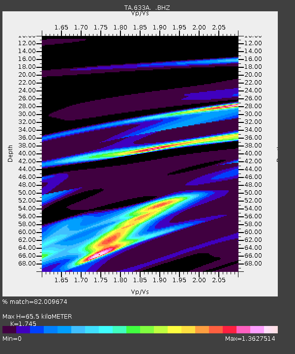
| Estimated Moho Depth: |
65.5 km |
| Estimated Crust Vp/Vs: |
1.75 |
| Assumed Crust Vp: |
6.347 km/s |
| Estimated Crust Vs: |
3.637 km/s |
| Estimated Crust Poisson's Ratio: |
0.26 |
|
| Radial Match: |
82.009674 % |
| Radial Bump: |
400 |
| Transverse Match: |
39.794155 % |
| Transverse Bump: |
400 |
| SOD ConfigId: |
356183 |
| Insert Time: |
2011-08-12 23:51:26.360 +0000 |
| GWidth: |
2.5 |
| Max Bumps: |
400 |
| Tol: |
0.001 |
|
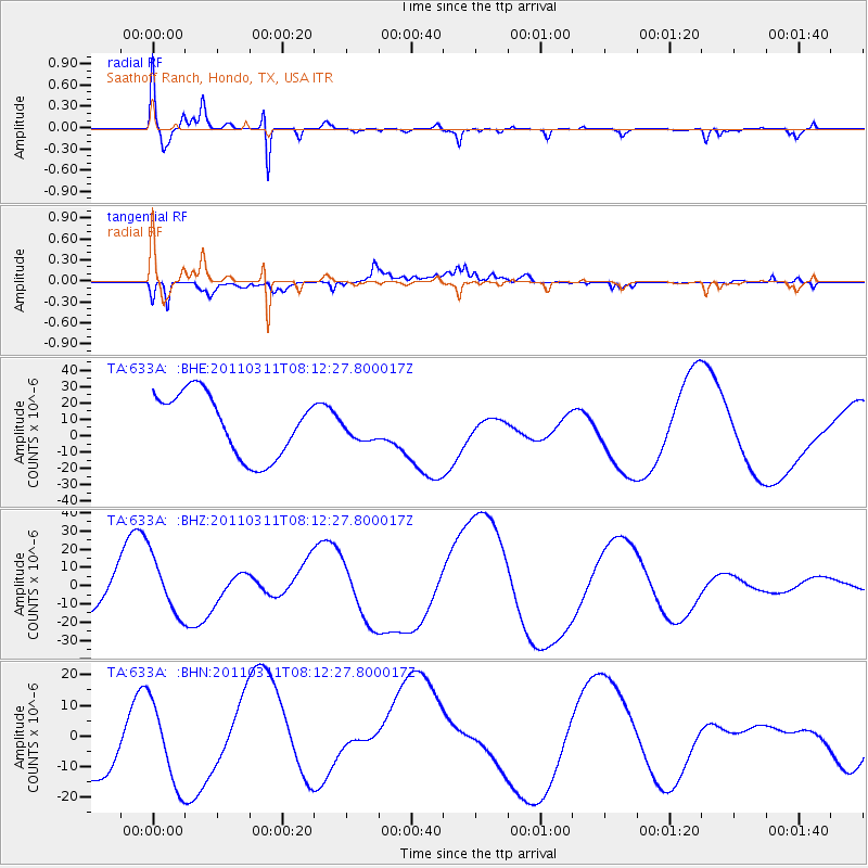
Signal To Noise
| Channel | StoN | STA | LTA |
| TA:633A: :BHZ:20110311T08:12:27.800017Z | 1.244896 | 1.5343649E-5 | 1.2325245E-5 |
| TA:633A: :BHN:20110311T08:12:27.800017Z | 1.4424751 | 1.33468175E-5 | 9.25272E-6 |
| TA:633A: :BHE:20110311T08:12:27.800017Z | 0.3997749 | 7.6094725E-6 | 1.9034393E-5 |
| Arrivals |
| Ps | 7.8 SECOND |
| PpPs | 28 SECOND |
| PsPs/PpSs | 36 SECOND |


