You are here: Home > Network List > TA - USArray Transportable Network (new EarthScope stations) Stations List
> Station 339A Huntington, TX, USA > Earthquake Result Viewer
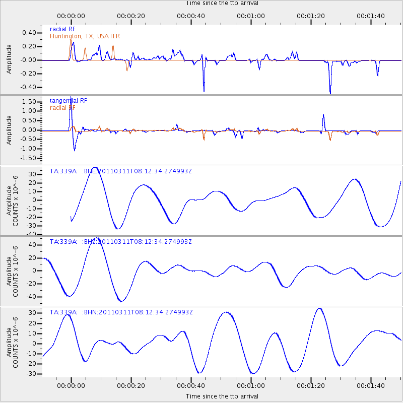
339A Huntington, TX, USA - Earthquake Result Viewer
*The percent match for this event was below the threshold and hence no stack was calculated.
| Earthquake location: |
Off East Coast Of Honshu, Japan |
| Earthquake latitude/longitude: |
37.0/142.8 |
| Earthquake time(UTC): |
2011/03/11 (070) 07:59:48 GMT |
| Earthquake Depth: |
0.7 km |
| Earthquake Magnitude: |
5.7 MB |
| Earthquake Catalog/Contributor: |
WHDF/NEIC |
|
| Network: |
TA USArray Transportable Network (new EarthScope stations) |
| Station: |
339A Huntington, TX, USA |
| Lat/Lon: |
31.33 N/94.56 W |
| Elevation: |
82 m |
|
| Distance: |
93.4 deg |
| Az: |
46.191 deg |
| Baz: |
317.542 deg |
| Ray Param: |
$rayparam |
*The percent match for this event was below the threshold and hence was not used in the summary stack. |
|
| Radial Match: |
86.43121 % |
| Radial Bump: |
341 |
| Transverse Match: |
53.79615 % |
| Transverse Bump: |
400 |
| SOD ConfigId: |
356183 |
| Insert Time: |
2011-08-12 23:53:12.345 +0000 |
| GWidth: |
2.5 |
| Max Bumps: |
400 |
| Tol: |
0.001 |
|
Signal To Noise
| Channel | StoN | STA | LTA |
| TA:339A: :BHZ:20110311T08:12:34.274993Z | 3.7631283 | 2.923458E-5 | 7.768691E-6 |
| TA:339A: :BHN:20110311T08:12:34.274993Z | 1.0503063 | 1.959292E-5 | 1.8654484E-5 |
| TA:339A: :BHE:20110311T08:12:34.274993Z | 0.95306426 | 2.1207878E-5 | 2.2252305E-5 |
| Arrivals |
| Ps | |
| PpPs | |
| PsPs/PpSs | |


