You are here: Home > Network List > TA - USArray Transportable Network (new EarthScope stations) Stations List
> Station T35A Sooner Cattle Company, Foraker, OK, USA > Earthquake Result Viewer
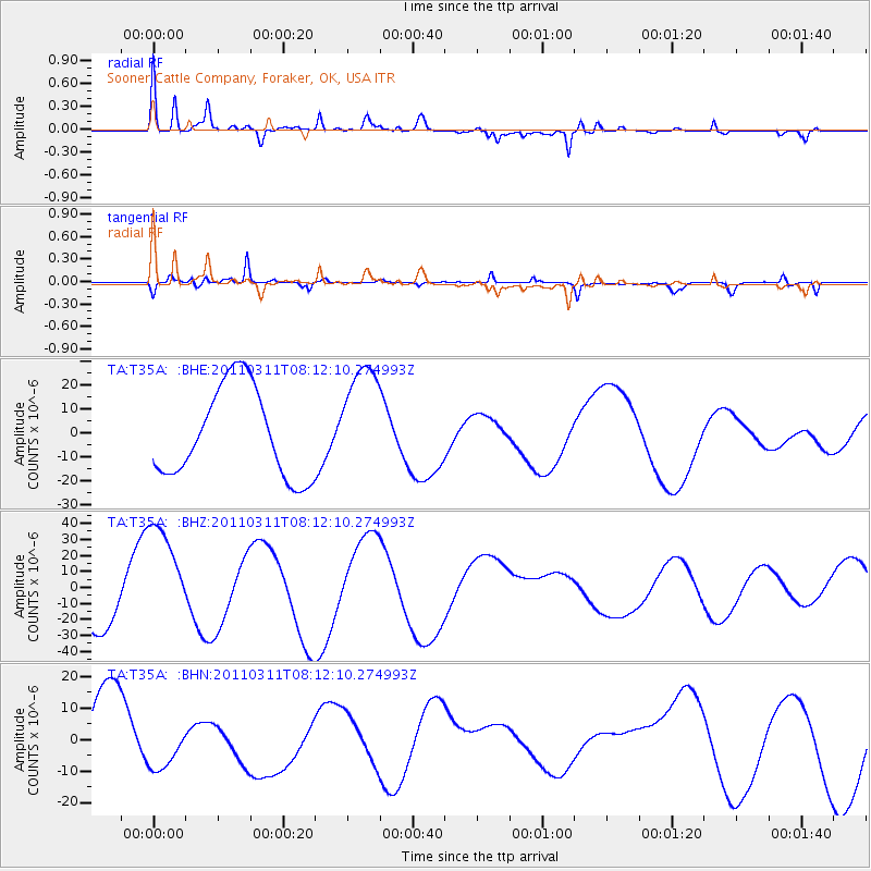
T35A Sooner Cattle Company, Foraker, OK, USA - Earthquake Result Viewer
*The percent match for this event was below the threshold and hence no stack was calculated.
| Earthquake location: |
Off East Coast Of Honshu, Japan |
| Earthquake latitude/longitude: |
37.0/142.8 |
| Earthquake time(UTC): |
2011/03/11 (070) 07:59:48 GMT |
| Earthquake Depth: |
0.7 km |
| Earthquake Magnitude: |
5.7 MB |
| Earthquake Catalog/Contributor: |
WHDF/NEIC |
|
| Network: |
TA USArray Transportable Network (new EarthScope stations) |
| Station: |
T35A Sooner Cattle Company, Foraker, OK, USA |
| Lat/Lon: |
36.92 N/96.51 W |
| Elevation: |
401 m |
|
| Distance: |
88.2 deg |
| Az: |
43.583 deg |
| Baz: |
316.485 deg |
| Ray Param: |
$rayparam |
*The percent match for this event was below the threshold and hence was not used in the summary stack. |
|
| Radial Match: |
70.36852 % |
| Radial Bump: |
398 |
| Transverse Match: |
59.35355 % |
| Transverse Bump: |
283 |
| SOD ConfigId: |
356183 |
| Insert Time: |
2011-08-12 23:55:59.888 +0000 |
| GWidth: |
2.5 |
| Max Bumps: |
400 |
| Tol: |
0.001 |
|
Signal To Noise
| Channel | StoN | STA | LTA |
| TA:T35A: :BHZ:20110311T08:12:10.274993Z | 2.7425852 | 3.57398E-5 | 1.3031427E-5 |
| TA:T35A: :BHN:20110311T08:12:10.274993Z | 0.7839797 | 8.625935E-6 | 1.1002753E-5 |
| TA:T35A: :BHE:20110311T08:12:10.274993Z | 1.2617861 | 2.3444625E-5 | 1.8580507E-5 |
| Arrivals |
| Ps | |
| PpPs | |
| PsPs/PpSs | |


