You are here: Home > Network List > TA - USArray Transportable Network (new EarthScope stations) Stations List
> Station H36A Jessenland, Henderson, MN, USA > Earthquake Result Viewer
H36A Jessenland, Henderson, MN, USA - Earthquake Result Viewer
| Earthquake location: |
Off East Coast Of Honshu, Japan |
| Earthquake latitude/longitude: |
37.0/142.8 |
| Earthquake time(UTC): |
2011/03/11 (070) 07:59:48 GMT |
| Earthquake Depth: |
0.7 km |
| Earthquake Magnitude: |
5.7 MB |
| Earthquake Catalog/Contributor: |
WHDF/NEIC |
|
| Network: |
TA USArray Transportable Network (new EarthScope stations) |
| Station: |
H36A Jessenland, Henderson, MN, USA |
| Lat/Lon: |
44.58 N/93.93 W |
| Elevation: |
311 m |
|
| Distance: |
84.0 deg |
| Az: |
36.921 deg |
| Baz: |
317.715 deg |
| Ray Param: |
0.045834757 |
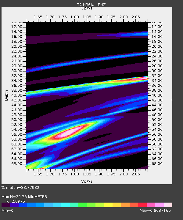
| Estimated Moho Depth: |
32.75 km |
| Estimated Crust Vp/Vs: |
2.10 |
| Assumed Crust Vp: |
6.571 km/s |
| Estimated Crust Vs: |
3.133 km/s |
| Estimated Crust Poisson's Ratio: |
0.35 |
|
| Radial Match: |
83.77932 % |
| Radial Bump: |
400 |
| Transverse Match: |
65.43916 % |
| Transverse Bump: |
277 |
| SOD ConfigId: |
356183 |
| Insert Time: |
2011-08-13 00:05:04.559 +0000 |
| GWidth: |
2.5 |
| Max Bumps: |
400 |
| Tol: |
0.001 |
|

Signal To Noise
| Channel | StoN | STA | LTA |
| TA:H36A: :BHZ:20110311T08:11:49.250029Z | 0.66239357 | 2.6274654E-5 | 3.9666225E-5 |
| TA:H36A: :BHN:20110311T08:11:49.250029Z | 0.57316375 | 9.549321E-6 | 1.6660719E-5 |
| TA:H36A: :BHE:20110311T08:11:49.250029Z | 1.8823677 | 3.19046E-5 | 1.6949185E-5 |
| Arrivals |
| Ps | 5.6 SECOND |
| PpPs | 15 SECOND |
| PsPs/PpSs | 21 SECOND |


