You are here: Home > Network List > IU - Global Seismograph Network (GSN - IRIS/USGS) Stations List
> Station PAYG Puerto Ayora, Galapagos Islands > Earthquake Result Viewer
PAYG Puerto Ayora, Galapagos Islands - Earthquake Result Viewer
| Earthquake location: |
South Of Kermadec Islands |
| Earthquake latitude/longitude: |
-32.9/-177.9 |
| Earthquake time(UTC): |
2014/02/02 (033) 09:26:37 GMT |
| Earthquake Depth: |
44 km |
| Earthquake Magnitude: |
6.5 MWW, 6.5 MWC, 6.5 MI |
| Earthquake Catalog/Contributor: |
NEIC PDE/NEIC COMCAT |
|
| Network: |
IU Global Seismograph Network (GSN - IRIS/USGS) |
| Station: |
PAYG Puerto Ayora, Galapagos Islands |
| Lat/Lon: |
0.67 S/90.29 W |
| Elevation: |
270 m |
|
| Distance: |
87.6 deg |
| Az: |
89.262 deg |
| Baz: |
237.266 deg |
| Ray Param: |
0.043128617 |
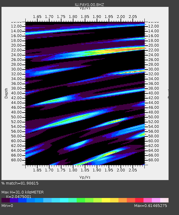
| Estimated Moho Depth: |
31.0 km |
| Estimated Crust Vp/Vs: |
2.05 |
| Assumed Crust Vp: |
4.802 km/s |
| Estimated Crust Vs: |
2.345 km/s |
| Estimated Crust Poisson's Ratio: |
0.34 |
|
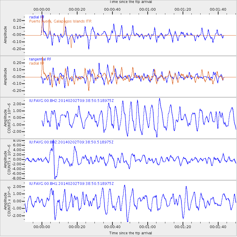
| Radial Match: |
81.98615 % |
| Radial Bump: |
400 |
| Transverse Match: |
62.80754 % |
| Transverse Bump: |
391 |
| SOD ConfigId: |
3390531 |
| Insert Time: |
2019-04-10 04:49:37.759 +0000 |
| GWidth: |
2.5 |
| Max Bumps: |
400 |
| Tol: |
0.001 |
|
Signal To Noise
| Channel | StoN | STA | LTA |
| IU:PAYG:00:BHZ:20140202T09:38:50.518975Z | 2.0948973 | 1.1271219E-6 | 5.38032E-7 |
| IU:PAYG:00:BH1:20140202T09:38:50.518975Z | 0.9379066 | 5.0034646E-7 | 5.334715E-7 |
| IU:PAYG:00:BH2:20140202T09:38:50.518975Z | 0.8021379 | 6.5783075E-7 | 8.2009683E-7 |
| Arrivals |
| Ps | 6.8 SECOND |
| PpPs | 19 SECOND |
| PsPs/PpSs | 26 SECOND |


