You are here: Home > Network List > TA - USArray Transportable Network (new EarthScope stations) Stations List
> Station Q24A Divide, CO, USA > Earthquake Result Viewer
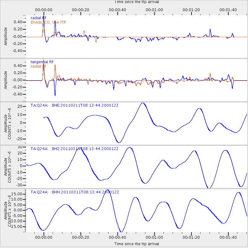
Q24A Divide, CO, USA - Earthquake Result Viewer
*The percent match for this event was below the threshold and hence no stack was calculated.
| Earthquake location: |
Off East Coast Of Honshu, Japan |
| Earthquake latitude/longitude: |
36.9/142.7 |
| Earthquake time(UTC): |
2011/03/11 (070) 08:01:57 GMT |
| Earthquake Depth: |
19 km |
| Earthquake Magnitude: |
5.9 MB |
| Earthquake Catalog/Contributor: |
WHDF/NEIC |
|
| Network: |
TA USArray Transportable Network (new EarthScope stations) |
| Station: |
Q24A Divide, CO, USA |
| Lat/Lon: |
38.96 N/105.15 W |
| Elevation: |
2775 m |
|
| Distance: |
82.0 deg |
| Az: |
46.816 deg |
| Baz: |
311.461 deg |
| Ray Param: |
$rayparam |
*The percent match for this event was below the threshold and hence was not used in the summary stack. |
|
| Radial Match: |
59.158497 % |
| Radial Bump: |
400 |
| Transverse Match: |
71.390976 % |
| Transverse Bump: |
373 |
| SOD ConfigId: |
356183 |
| Insert Time: |
2011-08-13 01:18:17.147 +0000 |
| GWidth: |
2.5 |
| Max Bumps: |
400 |
| Tol: |
0.001 |
|
Signal To Noise
| Channel | StoN | STA | LTA |
| TA:Q24A: :BHZ:20110311T08:13:44.200012Z | 1.2425824 | 1.31393845E-5 | 1.0574256E-5 |
| TA:Q24A: :BHN:20110311T08:13:44.200012Z | 3.035122 | 2.0873398E-5 | 6.877285E-6 |
| TA:Q24A: :BHE:20110311T08:13:44.200012Z | 1.5262408 | 1.1425897E-5 | 7.4863005E-6 |
| Arrivals |
| Ps | |
| PpPs | |
| PsPs/PpSs | |


