You are here: Home > Network List > AZ - ANZA Regional Network Stations List
> Station LVA2 AZ.LVA2 > Earthquake Result Viewer
LVA2 AZ.LVA2 - Earthquake Result Viewer
| Earthquake location: |
Near Coast Of Peru |
| Earthquake latitude/longitude: |
-17.4/-72.2 |
| Earthquake time(UTC): |
2001/06/23 (174) 20:56:07 GMT |
| Earthquake Depth: |
33 km |
| Earthquake Magnitude: |
5.8 MB |
| Earthquake Catalog/Contributor: |
WHDF/NEIC |
|
| Network: |
AZ ANZA Regional Network |
| Station: |
LVA2 AZ.LVA2 |
| Lat/Lon: |
33.35 N/116.56 W |
| Elevation: |
1435 m |
|
| Distance: |
65.9 deg |
| Az: |
320.095 deg |
| Baz: |
132.962 deg |
| Ray Param: |
0.057918675 |
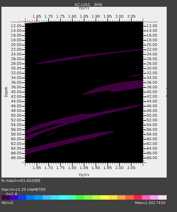
| Estimated Moho Depth: |
10.25 km |
| Estimated Crust Vp/Vs: |
1.60 |
| Assumed Crust Vp: |
6.264 km/s |
| Estimated Crust Vs: |
3.915 km/s |
| Estimated Crust Poisson's Ratio: |
0.18 |
|
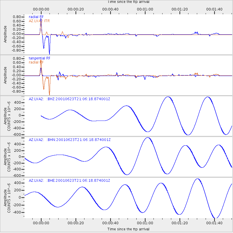
| Radial Match: |
93.482895 % |
| Radial Bump: |
400 |
| Transverse Match: |
88.510864 % |
| Transverse Bump: |
400 |
| SOD ConfigId: |
3753 |
| Insert Time: |
2010-02-26 19:44:12.696 +0000 |
| GWidth: |
2.5 |
| Max Bumps: |
400 |
| Tol: |
0.001 |
|
Signal To Noise
| Channel | StoN | STA | LTA |
| AZ:LVA2: :BHN:20010623T21:06:18.874001Z | 0.94386137 | 9.627091E-5 | 1.0199688E-4 |
| AZ:LVA2: :BHE:20010623T21:06:18.874001Z | 1.0224057 | 7.344803E-5 | 7.183844E-5 |
| AZ:LVA2: :BHZ:20010623T21:06:18.874001Z | 1.9130623 | 1.911535E-4 | 9.992016E-5 |
| Arrivals |
| Ps | 1.0 SECOND |
| PpPs | 4.1 SECOND |
| PsPs/PpSs | 5.1 SECOND |


