You are here: Home > Network List > TO - Tectonic Observatory Stations List
> Station CC34 CCSE CC34 > Earthquake Result Viewer
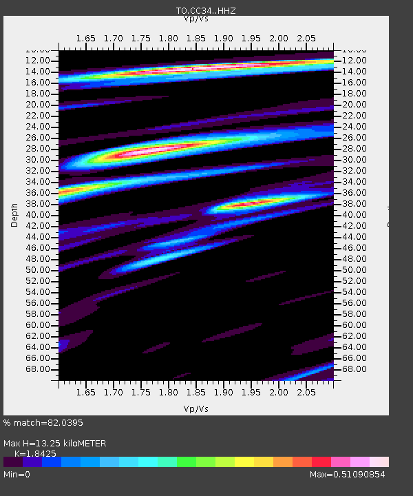
CC34 CCSE CC34 - Earthquake Result Viewer
| Earthquake location: |
South Of Kermadec Islands |
| Earthquake latitude/longitude: |
-32.9/-177.9 |
| Earthquake time(UTC): |
2014/02/02 (033) 09:26:37 GMT |
| Earthquake Depth: |
44 km |
| Earthquake Magnitude: |
6.5 MWW, 6.5 MWC, 6.5 MI |
| Earthquake Catalog/Contributor: |
NEIC PDE/NEIC COMCAT |
|
| Network: |
TO Tectonic Observatory |
| Station: |
CC34 CCSE CC34 |
| Lat/Lon: |
36.36 N/119.06 W |
| Elevation: |
173 m |
|
| Distance: |
88.1 deg |
| Az: |
43.708 deg |
| Baz: |
226.062 deg |
| Ray Param: |
0.042734172 |
| Estimated Moho Depth: |
13.25 km |
| Estimated Crust Vp/Vs: |
1.84 |
| Assumed Crust Vp: |
6.291 km/s |
| Estimated Crust Vs: |
3.415 km/s |
| Estimated Crust Poisson's Ratio: |
0.29 |
|
| Radial Match: |
82.0395 % |
| Radial Bump: |
400 |
| Transverse Match: |
67.41484 % |
| Transverse Bump: |
400 |
| SOD ConfigId: |
3390531 |
| Insert Time: |
2019-04-10 04:50:40.604 +0000 |
| GWidth: |
2.5 |
| Max Bumps: |
400 |
| Tol: |
0.001 |
|

Signal To Noise
| Channel | StoN | STA | LTA |
| TO:CC34: :HHZ:20140202T09:38:53.150017Z | 8.454419 | 1.8111757E-6 | 2.1422828E-7 |
| TO:CC34: :HHN:20140202T09:38:53.150017Z | 5.498295 | 4.9152175E-7 | 8.939531E-8 |
| TO:CC34: :HHE:20140202T09:38:53.150017Z | 1.929809 | 2.9453514E-7 | 1.52624E-7 |
| Arrivals |
| Ps | 1.8 SECOND |
| PpPs | 5.9 SECOND |
| PsPs/PpSs | 7.7 SECOND |


