You are here: Home > Network List > TA - USArray Transportable Network (new EarthScope stations) Stations List
> Station R37A Teagarden Farms, La Cygne, KS, USA > Earthquake Result Viewer
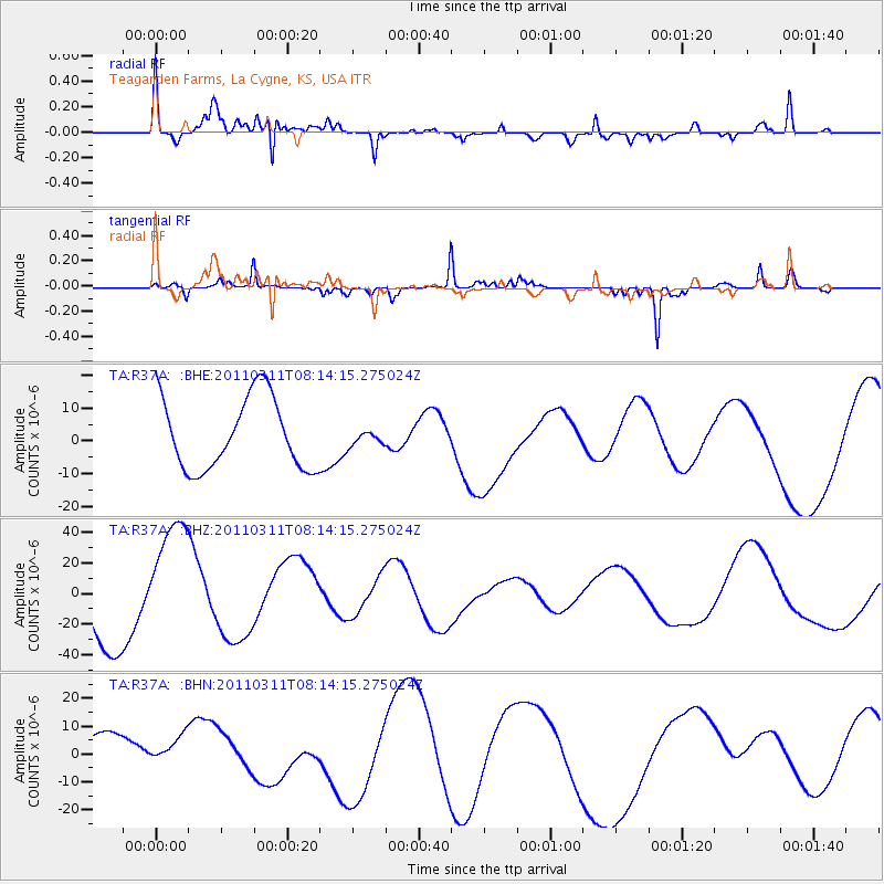
R37A Teagarden Farms, La Cygne, KS, USA - Earthquake Result Viewer
| Earthquake location: |
Off East Coast Of Honshu, Japan |
| Earthquake latitude/longitude: |
36.9/142.7 |
| Earthquake time(UTC): |
2011/03/11 (070) 08:01:57 GMT |
| Earthquake Depth: |
19 km |
| Earthquake Magnitude: |
5.9 MB |
| Earthquake Catalog/Contributor: |
WHDF/NEIC |
|
| Network: |
TA USArray Transportable Network (new EarthScope stations) |
| Station: |
R37A Teagarden Farms, La Cygne, KS, USA |
| Lat/Lon: |
38.31 N/94.83 W |
| Elevation: |
298 m |
|
| Distance: |
88.2 deg |
| Az: |
41.605 deg |
| Baz: |
317.444 deg |
| Ray Param: |
0.042731278 |
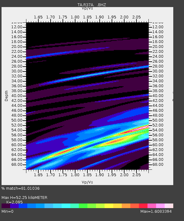
| Estimated Moho Depth: |
52.25 km |
| Estimated Crust Vp/Vs: |
2.10 |
| Assumed Crust Vp: |
6.498 km/s |
| Estimated Crust Vs: |
3.101 km/s |
| Estimated Crust Poisson's Ratio: |
0.35 |
|
| Radial Match: |
81.01036 % |
| Radial Bump: |
400 |
| Transverse Match: |
65.45282 % |
| Transverse Bump: |
158 |
| SOD ConfigId: |
356183 |
| Insert Time: |
2011-08-13 01:40:10.358 +0000 |
| GWidth: |
2.5 |
| Max Bumps: |
400 |
| Tol: |
0.001 |
|
Signal To Noise
| Channel | StoN | STA | LTA |
| TA:R37A: :BHZ:20110311T08:14:15.275024Z | 2.355874 | 3.9816474E-5 | 1.6900934E-5 |
| TA:R37A: :BHN:20110311T08:14:15.275024Z | 0.9055261 | 7.081277E-6 | 7.820069E-6 |
| TA:R37A: :BHE:20110311T08:14:15.275024Z | 0.1924019 | 2.0877203E-6 | 1.085083E-5 |
| Arrivals |
| Ps | 9.0 SECOND |
| PpPs | 24 SECOND |
| PsPs/PpSs | 33 SECOND |


