You are here: Home > Network List > TA - USArray Transportable Network (new EarthScope stations) Stations List
> Station I34A Hadley, MN, USA > Earthquake Result Viewer
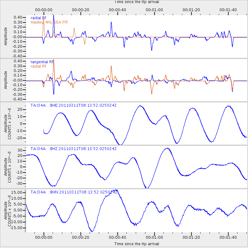
I34A Hadley, MN, USA - Earthquake Result Viewer
*The percent match for this event was below the threshold and hence no stack was calculated.
| Earthquake location: |
Off East Coast Of Honshu, Japan |
| Earthquake latitude/longitude: |
36.9/142.7 |
| Earthquake time(UTC): |
2011/03/11 (070) 08:01:57 GMT |
| Earthquake Depth: |
19 km |
| Earthquake Magnitude: |
5.9 MB |
| Earthquake Catalog/Contributor: |
WHDF/NEIC |
|
| Network: |
TA USArray Transportable Network (new EarthScope stations) |
| Station: |
I34A Hadley, MN, USA |
| Lat/Lon: |
44.04 N/95.86 W |
| Elevation: |
509 m |
|
| Distance: |
83.5 deg |
| Az: |
38.264 deg |
| Baz: |
316.526 deg |
| Ray Param: |
$rayparam |
*The percent match for this event was below the threshold and hence was not used in the summary stack. |
|
| Radial Match: |
81.37766 % |
| Radial Bump: |
387 |
| Transverse Match: |
41.890736 % |
| Transverse Bump: |
275 |
| SOD ConfigId: |
356183 |
| Insert Time: |
2011-08-13 01:46:04.816 +0000 |
| GWidth: |
2.5 |
| Max Bumps: |
400 |
| Tol: |
0.001 |
|
Signal To Noise
| Channel | StoN | STA | LTA |
| TA:I34A: :BHZ:20110311T08:13:52.025024Z | 1.4908907 | 2.6452235E-5 | 1.7742572E-5 |
| TA:I34A: :BHN:20110311T08:13:52.025024Z | 0.28342763 | 3.882133E-6 | 1.36970875E-5 |
| TA:I34A: :BHE:20110311T08:13:52.025024Z | 0.37929723 | 4.284172E-6 | 1.12950265E-5 |
| Arrivals |
| Ps | |
| PpPs | |
| PsPs/PpSs | |


