You are here: Home > Network List > TA - USArray Transportable Network (new EarthScope stations) Stations List
> Station 140A Cam and Jess, Hughton, LA, USA > Earthquake Result Viewer
140A Cam and Jess, Hughton, LA, USA - Earthquake Result Viewer

| Earthquake location: |
Off East Coast Of Honshu, Japan |
| Earthquake latitude/longitude: |
36.9/142.7 |
| Earthquake time(UTC): |
2011/03/11 (070) 08:01:57 GMT |
| Earthquake Depth: |
19 km |
| Earthquake Magnitude: |
5.9 MB |
| Earthquake Catalog/Contributor: |
WHDF/NEIC |
|
| Network: |
TA USArray Transportable Network (new EarthScope stations) |
| Station: |
140A Cam and Jess, Hughton, LA, USA |
| Lat/Lon: |
32.64 N/93.57 W |
| Elevation: |
56 m |
|
| Distance: |
93.1 deg |
| Az: |
44.648 deg |
| Baz: |
318.135 deg |
| Ray Param: |
0.041322716 |
| Estimated Moho Depth: |
68.0 km |
| Estimated Crust Vp/Vs: |
1.90 |
| Assumed Crust Vp: |
6.245 km/s |
| Estimated Crust Vs: |
3.287 km/s |
| Estimated Crust Poisson's Ratio: |
0.31 |
|
| Radial Match: |
82.49387 % |
| Radial Bump: |
335 |
| Transverse Match: |
67.901794 % |
| Transverse Bump: |
400 |
| SOD ConfigId: |
356183 |
| Insert Time: |
2011-08-13 01:58:05.890 +0000 |
| GWidth: |
2.5 |
| Max Bumps: |
400 |
| Tol: |
0.001 |
|
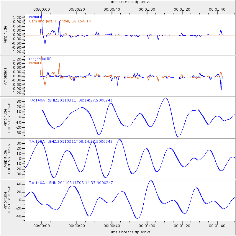
Signal To Noise
| Channel | StoN | STA | LTA |
| TA:140A: :BHZ:20110311T08:14:37.900024Z | 3.2124832 | 2.5532734E-5 | 7.947974E-6 |
| TA:140A: :BHN:20110311T08:14:37.900024Z | 1.3699338 | 1.2473295E-5 | 9.105035E-6 |
| TA:140A: :BHE:20110311T08:14:37.900024Z | 1.7600039 | 2.4594385E-5 | 1.3974051E-5 |
| Arrivals |
| Ps | 10.0 SECOND |
| PpPs | 31 SECOND |
| PsPs/PpSs | 41 SECOND |


