You are here: Home > Network List > YT07 - POLENET Stations List
> Station DNTW DNTW > Earthquake Result Viewer
DNTW DNTW - Earthquake Result Viewer
| Earthquake location: |
South Of Kermadec Islands |
| Earthquake latitude/longitude: |
-32.9/-177.9 |
| Earthquake time(UTC): |
2014/02/02 (033) 09:26:37 GMT |
| Earthquake Depth: |
44 km |
| Earthquake Magnitude: |
6.5 MWW, 6.5 MWC, 6.5 MI |
| Earthquake Catalog/Contributor: |
NEIC PDE/NEIC COMCAT |
|
| Network: |
YT POLENET |
| Station: |
DNTW DNTW |
| Lat/Lon: |
76.45 S/107.78 W |
| Elevation: |
1031 m |
|
| Distance: |
53.6 deg |
| Az: |
164.019 deg |
| Baz: |
280.789 deg |
| Ray Param: |
0.06586593 |
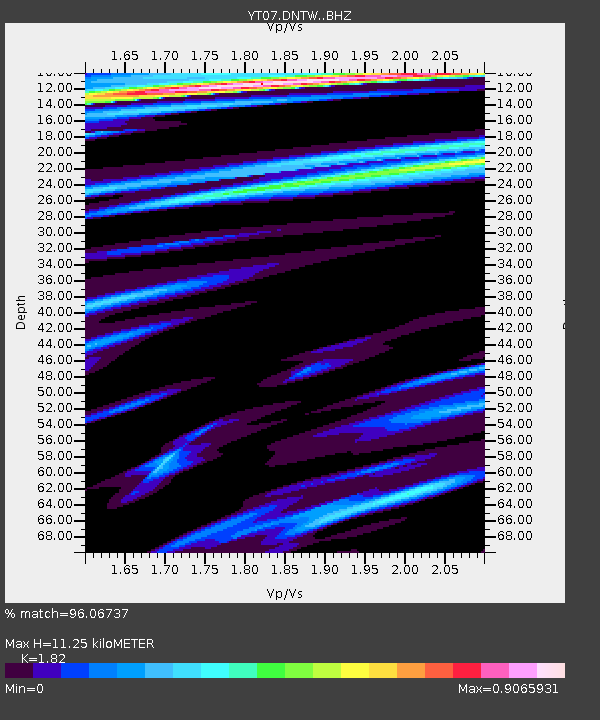
| Estimated Moho Depth: |
11.25 km |
| Estimated Crust Vp/Vs: |
1.82 |
| Assumed Crust Vp: |
5.951 km/s |
| Estimated Crust Vs: |
3.27 km/s |
| Estimated Crust Poisson's Ratio: |
0.28 |
|
| Radial Match: |
96.06737 % |
| Radial Bump: |
243 |
| Transverse Match: |
90.15051 % |
| Transverse Bump: |
338 |
| SOD ConfigId: |
3390531 |
| Insert Time: |
2019-04-10 04:51:11.359 +0000 |
| GWidth: |
2.5 |
| Max Bumps: |
400 |
| Tol: |
0.001 |
|

Signal To Noise
| Channel | StoN | STA | LTA |
| YT:DNTW: :BHZ:20140202T09:35:23.900017Z | 17.972359 | 2.2573636E-6 | 1.2560196E-7 |
| YT:DNTW: :BHN:20140202T09:35:23.900017Z | 6.3972135 | 6.880183E-7 | 1.0754968E-7 |
| YT:DNTW: :BHE:20140202T09:35:23.900017Z | 11.922695 | 1.6595712E-6 | 1.391943E-7 |
| Arrivals |
| Ps | 1.6 SECOND |
| PpPs | 5.1 SECOND |
| PsPs/PpSs | 6.7 SECOND |


