You are here: Home > Network List > YT07 - POLENET Stations List
> Station HOWE HOWE > Earthquake Result Viewer
HOWE HOWE - Earthquake Result Viewer
| Earthquake location: |
South Of Kermadec Islands |
| Earthquake latitude/longitude: |
-32.9/-177.9 |
| Earthquake time(UTC): |
2014/02/02 (033) 09:26:37 GMT |
| Earthquake Depth: |
44 km |
| Earthquake Magnitude: |
6.5 MWW, 6.5 MWC, 6.5 MI |
| Earthquake Catalog/Contributor: |
NEIC PDE/NEIC COMCAT |
|
| Network: |
YT POLENET |
| Station: |
HOWE HOWE |
| Lat/Lon: |
87.42 S/149.43 W |
| Elevation: |
2607 m |
|
| Distance: |
55.0 deg |
| Az: |
178.487 deg |
| Baz: |
330.703 deg |
| Ray Param: |
0.06498934 |
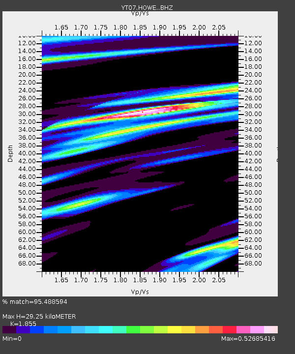
| Estimated Moho Depth: |
29.25 km |
| Estimated Crust Vp/Vs: |
1.86 |
| Assumed Crust Vp: |
6.182 km/s |
| Estimated Crust Vs: |
3.332 km/s |
| Estimated Crust Poisson's Ratio: |
0.30 |
|
| Radial Match: |
95.488594 % |
| Radial Bump: |
322 |
| Transverse Match: |
84.39109 % |
| Transverse Bump: |
400 |
| SOD ConfigId: |
3390531 |
| Insert Time: |
2019-04-10 04:51:14.514 +0000 |
| GWidth: |
2.5 |
| Max Bumps: |
400 |
| Tol: |
0.001 |
|

Signal To Noise
| Channel | StoN | STA | LTA |
| YT:HOWE: :BHZ:20140202T09:35:33.67498Z | 23.108347 | 2.4454794E-6 | 1.05826665E-7 |
| YT:HOWE: :BHN:20140202T09:35:33.67498Z | 13.0425005 | 1.0456531E-6 | 8.017275E-8 |
| YT:HOWE: :BHE:20140202T09:35:33.67498Z | 8.135177 | 6.273665E-7 | 7.711775E-8 |
| Arrivals |
| Ps | 4.2 SECOND |
| PpPs | 13 SECOND |
| PsPs/PpSs | 17 SECOND |


