You are here: Home > Network List > UW - Pacific Northwest Regional Seismic Network Stations List
> Station TAKO Tahkenitch, OR CREST BB SMO > Earthquake Result Viewer
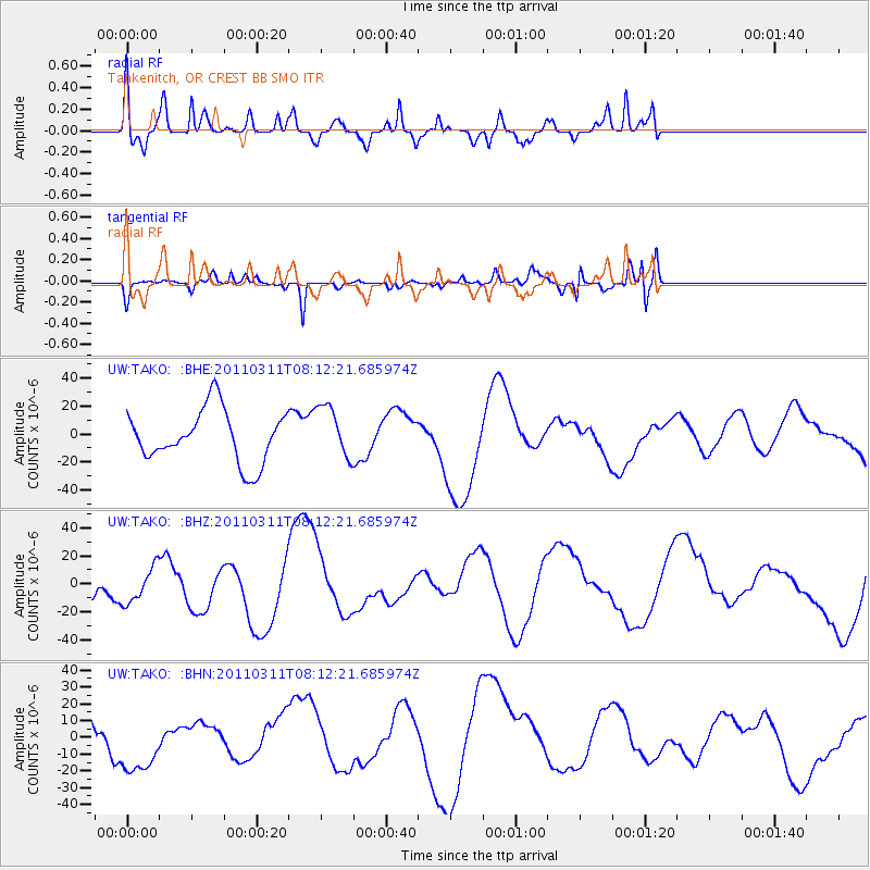
TAKO Tahkenitch, OR CREST BB SMO - Earthquake Result Viewer
*The percent match for this event was below the threshold and hence no stack was calculated.
| Earthquake location: |
Off East Coast Of Honshu, Japan |
| Earthquake latitude/longitude: |
36.9/142.7 |
| Earthquake time(UTC): |
2011/03/11 (070) 08:01:57 GMT |
| Earthquake Depth: |
19 km |
| Earthquake Magnitude: |
5.9 MB |
| Earthquake Catalog/Contributor: |
WHDF/NEIC |
|
| Network: |
UW Pacific Northwest Regional Seismic Network |
| Station: |
TAKO Tahkenitch, OR CREST BB SMO |
| Lat/Lon: |
43.74 N/124.08 W |
| Elevation: |
46 m |
|
| Distance: |
67.7 deg |
| Az: |
51.461 deg |
| Baz: |
300.149 deg |
| Ray Param: |
$rayparam |
*The percent match for this event was below the threshold and hence was not used in the summary stack. |
|
| Radial Match: |
79.4432 % |
| Radial Bump: |
400 |
| Transverse Match: |
54.813046 % |
| Transverse Bump: |
400 |
| SOD ConfigId: |
356183 |
| Insert Time: |
2011-08-13 02:07:34.470 +0000 |
| GWidth: |
2.5 |
| Max Bumps: |
400 |
| Tol: |
0.001 |
|
Signal To Noise
| Channel | StoN | STA | LTA |
| UW:TAKO: :BHZ:20110311T08:12:21.685974Z | 0.574773 | 1.3404774E-5 | 2.3321858E-5 |
| UW:TAKO: :BHN:20110311T08:12:21.685974Z | 2.3431456 | 1.8557219E-5 | 7.919789E-6 |
| UW:TAKO: :BHE:20110311T08:12:21.685974Z | 1.0110396 | 1.890883E-5 | 1.8702363E-5 |
| Arrivals |
| Ps | |
| PpPs | |
| PsPs/PpSs | |


