You are here: Home > Network List > TA - USArray Transportable Network (new EarthScope stations) Stations List
> Station H25A Fruitdale, SD, USA > Earthquake Result Viewer
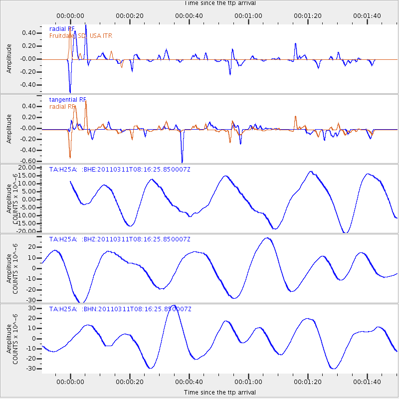
H25A Fruitdale, SD, USA - Earthquake Result Viewer
*The percent match for this event was below the threshold and hence no stack was calculated.
| Earthquake location: |
Off East Coast Of Honshu, Japan |
| Earthquake latitude/longitude: |
37.6/142.2 |
| Earthquake time(UTC): |
2011/03/11 (070) 08:04:58 GMT |
| Earthquake Depth: |
49 km |
| Earthquake Magnitude: |
5.7 MB |
| Earthquake Catalog/Contributor: |
WHDF/NEIC |
|
| Network: |
TA USArray Transportable Network (new EarthScope stations) |
| Station: |
H25A Fruitdale, SD, USA |
| Lat/Lon: |
44.62 N/103.60 W |
| Elevation: |
942 m |
|
| Distance: |
78.9 deg |
| Az: |
41.594 deg |
| Baz: |
312.403 deg |
| Ray Param: |
$rayparam |
*The percent match for this event was below the threshold and hence was not used in the summary stack. |
|
| Radial Match: |
64.90219 % |
| Radial Bump: |
400 |
| Transverse Match: |
62.570934 % |
| Transverse Bump: |
203 |
| SOD ConfigId: |
356183 |
| Insert Time: |
2011-08-13 03:13:39.337 +0000 |
| GWidth: |
2.5 |
| Max Bumps: |
400 |
| Tol: |
0.001 |
|
Signal To Noise
| Channel | StoN | STA | LTA |
| TA:H25A: :BHZ:20110311T08:16:25.850007Z | 4.3245397 | 2.7189884E-5 | 6.287348E-6 |
| TA:H25A: :BHN:20110311T08:16:25.850007Z | 0.6568783 | 6.7537376E-6 | 1.0281566E-5 |
| TA:H25A: :BHE:20110311T08:16:25.850007Z | 0.79204494 | 6.2922168E-6 | 7.944267E-6 |
| Arrivals |
| Ps | |
| PpPs | |
| PsPs/PpSs | |


