You are here: Home > Network List > TA - USArray Transportable Network (new EarthScope stations) Stations List
> Station F34A Alexandria, MN, USA > Earthquake Result Viewer
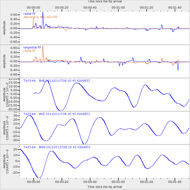
F34A Alexandria, MN, USA - Earthquake Result Viewer
*The percent match for this event was below the threshold and hence no stack was calculated.
| Earthquake location: |
Off East Coast Of Honshu, Japan |
| Earthquake latitude/longitude: |
37.6/142.2 |
| Earthquake time(UTC): |
2011/03/11 (070) 08:04:58 GMT |
| Earthquake Depth: |
49 km |
| Earthquake Magnitude: |
5.7 MB |
| Earthquake Catalog/Contributor: |
WHDF/NEIC |
|
| Network: |
TA USArray Transportable Network (new EarthScope stations) |
| Station: |
F34A Alexandria, MN, USA |
| Lat/Lon: |
45.80 N/95.26 W |
| Elevation: |
419 m |
|
| Distance: |
82.2 deg |
| Az: |
36.534 deg |
| Baz: |
317.477 deg |
| Ray Param: |
$rayparam |
*The percent match for this event was below the threshold and hence was not used in the summary stack. |
|
| Radial Match: |
68.219955 % |
| Radial Bump: |
377 |
| Transverse Match: |
83.9413 % |
| Transverse Bump: |
308 |
| SOD ConfigId: |
356183 |
| Insert Time: |
2011-08-13 03:34:55.073 +0000 |
| GWidth: |
2.5 |
| Max Bumps: |
400 |
| Tol: |
0.001 |
|
Signal To Noise
| Channel | StoN | STA | LTA |
| TA:F34A: :BHZ:20110311T08:16:43.699983Z | 0.8056155 | 1.4786975E-5 | 1.835488E-5 |
| TA:F34A: :BHN:20110311T08:16:43.699983Z | 2.227379 | 2.882832E-5 | 1.294271E-5 |
| TA:F34A: :BHE:20110311T08:16:43.699983Z | 1.2469335 | 1.6372336E-5 | 1.3130079E-5 |
| Arrivals |
| Ps | |
| PpPs | |
| PsPs/PpSs | |


