You are here: Home > Network List > TA - USArray Transportable Network (new EarthScope stations) Stations List
> Station R39A Chumby, Stover, MO, USA > Earthquake Result Viewer
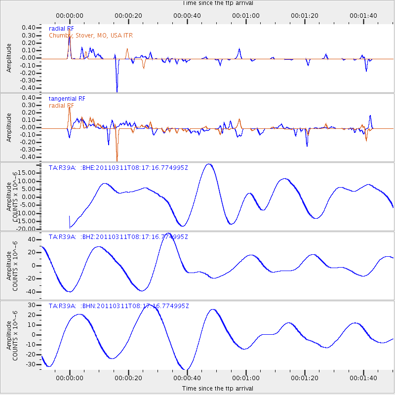
R39A Chumby, Stover, MO, USA - Earthquake Result Viewer
*The percent match for this event was below the threshold and hence no stack was calculated.
| Earthquake location: |
Off East Coast Of Honshu, Japan |
| Earthquake latitude/longitude: |
37.6/142.2 |
| Earthquake time(UTC): |
2011/03/11 (070) 08:04:58 GMT |
| Earthquake Depth: |
49 km |
| Earthquake Magnitude: |
5.7 MB |
| Earthquake Catalog/Contributor: |
WHDF/NEIC |
|
| Network: |
TA USArray Transportable Network (new EarthScope stations) |
| Station: |
R39A Chumby, Stover, MO, USA |
| Lat/Lon: |
38.31 N/93.04 W |
| Elevation: |
290 m |
|
| Distance: |
88.9 deg |
| Az: |
40.273 deg |
| Baz: |
319.251 deg |
| Ray Param: |
$rayparam |
*The percent match for this event was below the threshold and hence was not used in the summary stack. |
|
| Radial Match: |
93.27966 % |
| Radial Bump: |
190 |
| Transverse Match: |
82.988556 % |
| Transverse Bump: |
400 |
| SOD ConfigId: |
356183 |
| Insert Time: |
2011-08-13 03:38:15.033 +0000 |
| GWidth: |
2.5 |
| Max Bumps: |
400 |
| Tol: |
0.001 |
|
Signal To Noise
| Channel | StoN | STA | LTA |
| TA:R39A: :BHZ:20110311T08:17:16.774995Z | 2.037862 | 3.5120753E-5 | 1.7234117E-5 |
| TA:R39A: :BHN:20110311T08:17:16.774995Z | 1.4991724 | 2.2554996E-5 | 1.5044964E-5 |
| TA:R39A: :BHE:20110311T08:17:16.774995Z | 0.39028612 | 3.1295517E-6 | 8.018609E-6 |
| Arrivals |
| Ps | |
| PpPs | |
| PsPs/PpSs | |


