You are here: Home > Network List > AZ - ANZA Regional Network Stations List
> Station LVA2 AZ.LVA2 > Earthquake Result Viewer
LVA2 AZ.LVA2 - Earthquake Result Viewer

| Earthquake location: |
Near Coast Of Central Chile |
| Earthquake latitude/longitude: |
-30.8/-71.1 |
| Earthquake time(UTC): |
2002/06/18 (169) 13:56:22 GMT |
| Earthquake Depth: |
54 km |
| Earthquake Magnitude: |
6.0 MB, 6.6 MW, 6.4 MW |
| Earthquake Catalog/Contributor: |
WHDF/NEIC |
|
| Network: |
AZ ANZA Regional Network |
| Station: |
LVA2 AZ.LVA2 |
| Lat/Lon: |
33.35 N/116.56 W |
| Elevation: |
1435 m |
|
| Distance: |
76.9 deg |
| Az: |
322.247 deg |
| Baz: |
140.995 deg |
| Ray Param: |
0.050575938 |
| Estimated Moho Depth: |
15.0 km |
| Estimated Crust Vp/Vs: |
1.60 |
| Assumed Crust Vp: |
6.264 km/s |
| Estimated Crust Vs: |
3.915 km/s |
| Estimated Crust Poisson's Ratio: |
0.18 |
|
| Radial Match: |
92.834114 % |
| Radial Bump: |
400 |
| Transverse Match: |
88.088524 % |
| Transverse Bump: |
400 |
| SOD ConfigId: |
32974 |
| Insert Time: |
2010-02-26 19:44:44.587 +0000 |
| GWidth: |
2.5 |
| Max Bumps: |
400 |
| Tol: |
0.001 |
|
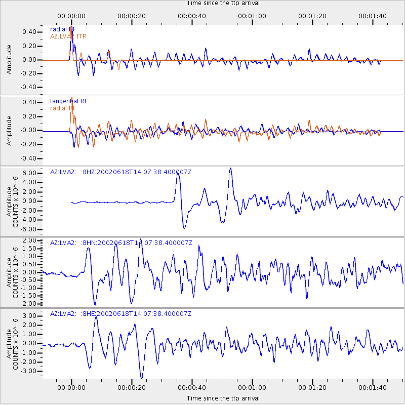
Signal To Noise
| Channel | StoN | STA | LTA |
| AZ:LVA2: :BHN:20020618T14:07:38.400007Z | 2.1155918 | 2.6732522E-7 | 1.2635954E-7 |
| AZ:LVA2: :BHE:20020618T14:07:38.400007Z | 1.0275406 | 1.7922862E-7 | 1.7442487E-7 |
| AZ:LVA2: :BHZ:20020618T14:07:38.400007Z | 9.891017 | 9.3769376E-7 | 9.480256E-8 |
| Arrivals |
| Ps | 1.5 SECOND |
| PpPs | 6.0 SECOND |
| PsPs/PpSs | 7.5 SECOND |


