You are here: Home > Network List > TA - USArray Transportable Network (new EarthScope stations) Stations List
> Station 139A Bunkhouse Ranch, Marshall, TX, USA > Earthquake Result Viewer
139A Bunkhouse Ranch, Marshall, TX, USA - Earthquake Result Viewer
| Earthquake location: |
Near East Coast Of Honshu, Japan |
| Earthquake latitude/longitude: |
36.3/140.9 |
| Earthquake time(UTC): |
2011/03/11 (070) 08:10:29 GMT |
| Earthquake Depth: |
20 km |
| Earthquake Magnitude: |
5.6 MB |
| Earthquake Catalog/Contributor: |
WHDF/NEIC |
|
| Network: |
TA USArray Transportable Network (new EarthScope stations) |
| Station: |
139A Bunkhouse Ranch, Marshall, TX, USA |
| Lat/Lon: |
32.68 N/94.39 W |
| Elevation: |
59 m |
|
| Distance: |
94.1 deg |
| Az: |
44.002 deg |
| Baz: |
318.277 deg |
| Ray Param: |
0.04111371 |
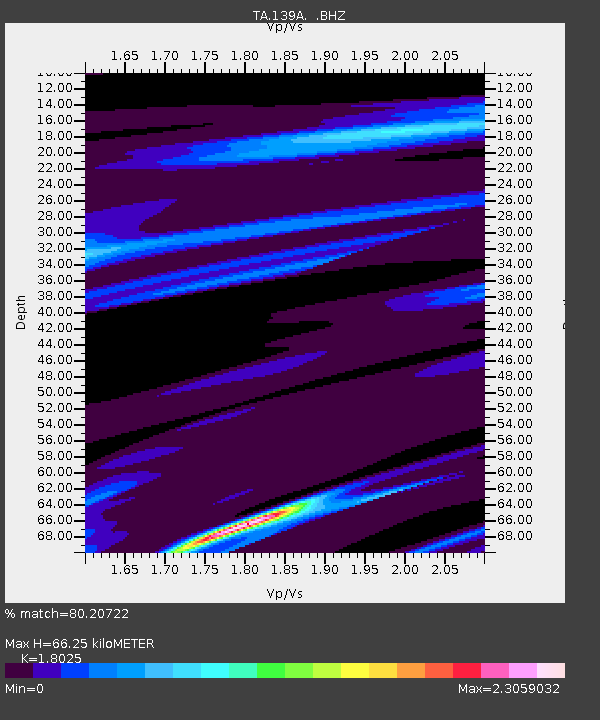
| Estimated Moho Depth: |
66.25 km |
| Estimated Crust Vp/Vs: |
1.80 |
| Assumed Crust Vp: |
6.245 km/s |
| Estimated Crust Vs: |
3.465 km/s |
| Estimated Crust Poisson's Ratio: |
0.28 |
|
| Radial Match: |
80.20722 % |
| Radial Bump: |
297 |
| Transverse Match: |
72.99514 % |
| Transverse Bump: |
400 |
| SOD ConfigId: |
356183 |
| Insert Time: |
2011-08-13 04:34:43.885 +0000 |
| GWidth: |
2.5 |
| Max Bumps: |
400 |
| Tol: |
0.001 |
|

Signal To Noise
| Channel | StoN | STA | LTA |
| TA:139A: :BHZ:20110311T08:23:14.85001Z | 1.7988472 | 2.9156974E-5 | 1.62087E-5 |
| TA:139A: :BHN:20110311T08:23:14.85001Z | 0.941687 | 1.0100389E-5 | 1.0725845E-5 |
| TA:139A: :BHE:20110311T08:23:14.85001Z | 1.6247456 | 1.653174E-5 | 1.0174971E-5 |
| Arrivals |
| Ps | 8.7 SECOND |
| PpPs | 29 SECOND |
| PsPs/PpSs | 38 SECOND |


