You are here: Home > Network List > IC - New China Digital Seismograph Network Stations List
> Station KMI Kunming, Yunnan Province, China > Earthquake Result Viewer
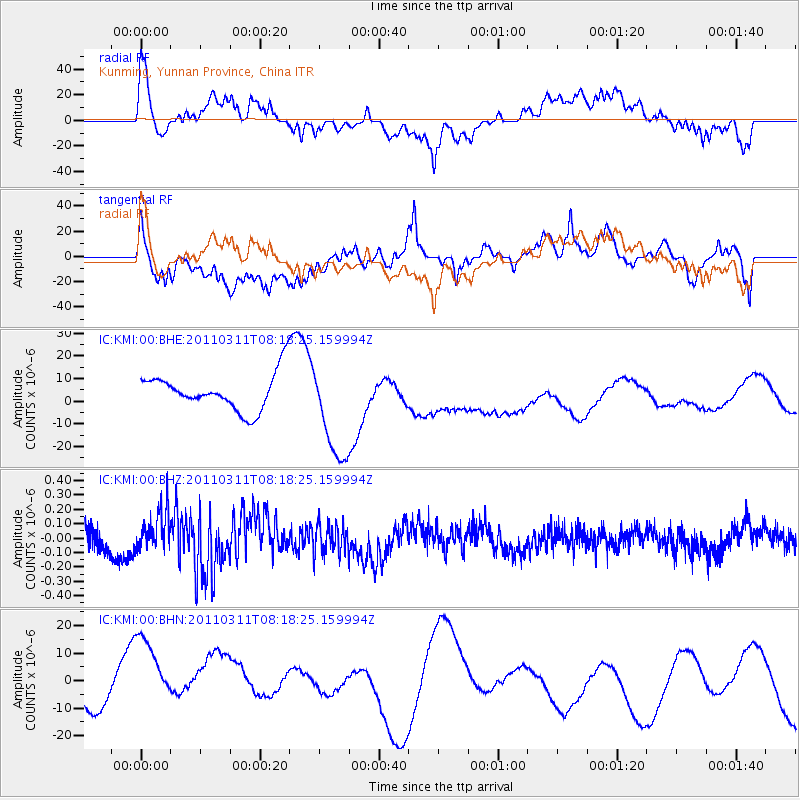
KMI Kunming, Yunnan Province, China - Earthquake Result Viewer
*The percent match for this event was below the threshold and hence no stack was calculated.
| Earthquake location: |
Near East Coast Of Honshu, Japan |
| Earthquake latitude/longitude: |
36.6/141.5 |
| Earthquake time(UTC): |
2011/03/11 (070) 08:12:07 GMT |
| Earthquake Depth: |
40 km |
| Earthquake Magnitude: |
6.2 MB |
| Earthquake Catalog/Contributor: |
WHDF/NEIC |
|
| Network: |
IC New China Digital Seismograph Network |
| Station: |
KMI Kunming, Yunnan Province, China |
| Lat/Lon: |
25.12 N/102.74 E |
| Elevation: |
1975 m |
|
| Distance: |
35.0 deg |
| Az: |
262.026 deg |
| Baz: |
61.583 deg |
| Ray Param: |
$rayparam |
*The percent match for this event was below the threshold and hence was not used in the summary stack. |
|
| Radial Match: |
78.158035 % |
| Radial Bump: |
400 |
| Transverse Match: |
61.053207 % |
| Transverse Bump: |
400 |
| SOD ConfigId: |
356183 |
| Insert Time: |
2011-08-13 05:26:02.569 +0000 |
| GWidth: |
2.5 |
| Max Bumps: |
400 |
| Tol: |
0.001 |
|
Signal To Noise
| Channel | StoN | STA | LTA |
| IC:KMI:00:BHZ:20110311T08:18:25.159994Z | 1.4205152 | 1.4003317E-7 | 9.8579136E-8 |
| IC:KMI:00:BHN:20110311T08:18:25.159994Z | 3.6848662 | 1.8861356E-5 | 5.1186003E-6 |
| IC:KMI:00:BHE:20110311T08:18:25.159994Z | 2.791673 | 2.2215183E-5 | 7.957659E-6 |
| Arrivals |
| Ps | |
| PpPs | |
| PsPs/PpSs | |


