You are here: Home > Network List > TA - USArray Transportable Network (new EarthScope stations) Stations List
> Station K35A Storm Lake, IA, USA > Earthquake Result Viewer
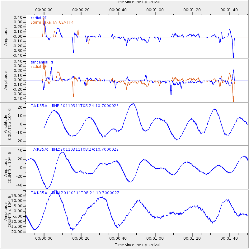
K35A Storm Lake, IA, USA - Earthquake Result Viewer
*The percent match for this event was below the threshold and hence no stack was calculated.
| Earthquake location: |
Near East Coast Of Honshu, Japan |
| Earthquake latitude/longitude: |
36.6/141.5 |
| Earthquake time(UTC): |
2011/03/11 (070) 08:12:07 GMT |
| Earthquake Depth: |
40 km |
| Earthquake Magnitude: |
6.2 MB |
| Earthquake Catalog/Contributor: |
WHDF/NEIC |
|
| Network: |
TA USArray Transportable Network (new EarthScope stations) |
| Station: |
K35A Storm Lake, IA, USA |
| Lat/Lon: |
42.72 N/95.23 W |
| Elevation: |
439 m |
|
| Distance: |
85.7 deg |
| Az: |
38.157 deg |
| Baz: |
317.551 deg |
| Ray Param: |
$rayparam |
*The percent match for this event was below the threshold and hence was not used in the summary stack. |
|
| Radial Match: |
61.054504 % |
| Radial Bump: |
400 |
| Transverse Match: |
63.895424 % |
| Transverse Bump: |
400 |
| SOD ConfigId: |
356183 |
| Insert Time: |
2011-08-13 06:02:47.535 +0000 |
| GWidth: |
2.5 |
| Max Bumps: |
400 |
| Tol: |
0.001 |
|
Signal To Noise
| Channel | StoN | STA | LTA |
| TA:K35A: :BHZ:20110311T08:24:10.700002Z | 3.710042 | 4.1770603E-5 | 1.1258795E-5 |
| TA:K35A: :BHN:20110311T08:24:10.700002Z | 2.7495894 | 1.3801189E-5 | 5.0193635E-6 |
| TA:K35A: :BHE:20110311T08:24:10.700002Z | 1.254626 | 1.2578164E-5 | 1.0025429E-5 |
| Arrivals |
| Ps | |
| PpPs | |
| PsPs/PpSs | |


