You are here: Home > Network List > TA - USArray Transportable Network (new EarthScope stations) Stations List
> Station H36A Jessenland, Henderson, MN, USA > Earthquake Result Viewer
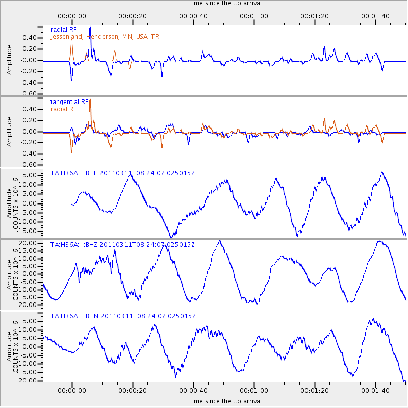
H36A Jessenland, Henderson, MN, USA - Earthquake Result Viewer
*The percent match for this event was below the threshold and hence no stack was calculated.
| Earthquake location: |
Near East Coast Of Honshu, Japan |
| Earthquake latitude/longitude: |
36.6/141.5 |
| Earthquake time(UTC): |
2011/03/11 (070) 08:12:07 GMT |
| Earthquake Depth: |
40 km |
| Earthquake Magnitude: |
6.2 MB |
| Earthquake Catalog/Contributor: |
WHDF/NEIC |
|
| Network: |
TA USArray Transportable Network (new EarthScope stations) |
| Station: |
H36A Jessenland, Henderson, MN, USA |
| Lat/Lon: |
44.58 N/93.93 W |
| Elevation: |
311 m |
|
| Distance: |
84.9 deg |
| Az: |
36.204 deg |
| Baz: |
318.289 deg |
| Ray Param: |
$rayparam |
*The percent match for this event was below the threshold and hence was not used in the summary stack. |
|
| Radial Match: |
80.860725 % |
| Radial Bump: |
380 |
| Transverse Match: |
38.42272 % |
| Transverse Bump: |
400 |
| SOD ConfigId: |
356183 |
| Insert Time: |
2011-08-13 06:08:21.634 +0000 |
| GWidth: |
2.5 |
| Max Bumps: |
400 |
| Tol: |
0.001 |
|
Signal To Noise
| Channel | StoN | STA | LTA |
| TA:H36A: :BHZ:20110311T08:24:07.025015Z | 0.36638194 | 4.332562E-6 | 1.1825262E-5 |
| TA:H36A: :BHN:20110311T08:24:07.025015Z | 0.4109964 | 3.2712828E-6 | 7.959395E-6 |
| TA:H36A: :BHE:20110311T08:24:07.025015Z | 2.9843519 | 1.709059E-5 | 5.726734E-6 |
| Arrivals |
| Ps | |
| PpPs | |
| PsPs/PpSs | |


