You are here: Home > Network List > AZ - ANZA Regional Network Stations List
> Station LVA2 AZ.LVA2 > Earthquake Result Viewer
LVA2 AZ.LVA2 - Earthquake Result Viewer
| Earthquake location: |
Chile-Bolivia Border Region |
| Earthquake latitude/longitude: |
-21.7/-68.3 |
| Earthquake time(UTC): |
2002/03/28 (087) 04:56:22 GMT |
| Earthquake Depth: |
125 km |
| Earthquake Magnitude: |
6.1 MB, 6.5 MW, 6.5 MW |
| Earthquake Catalog/Contributor: |
WHDF/NEIC |
|
| Network: |
AZ ANZA Regional Network |
| Station: |
LVA2 AZ.LVA2 |
| Lat/Lon: |
33.35 N/116.56 W |
| Elevation: |
1435 m |
|
| Distance: |
71.5 deg |
| Az: |
318.821 deg |
| Baz: |
132.967 deg |
| Ray Param: |
0.053984217 |
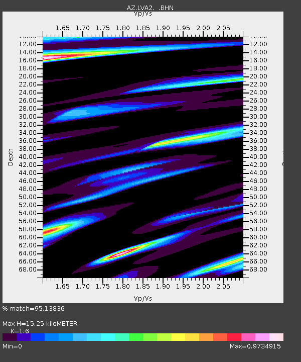
| Estimated Moho Depth: |
15.25 km |
| Estimated Crust Vp/Vs: |
1.60 |
| Assumed Crust Vp: |
6.264 km/s |
| Estimated Crust Vs: |
3.915 km/s |
| Estimated Crust Poisson's Ratio: |
0.18 |
|
| Radial Match: |
95.13836 % |
| Radial Bump: |
400 |
| Transverse Match: |
84.57884 % |
| Transverse Bump: |
400 |
| SOD ConfigId: |
32974 |
| Insert Time: |
2010-02-26 19:44:57.628 +0000 |
| GWidth: |
2.5 |
| Max Bumps: |
400 |
| Tol: |
0.001 |
|

Signal To Noise
| Channel | StoN | STA | LTA |
| AZ:LVA2: :BHN:20020328T05:06:58.475012Z | 1.5390111 | 4.492808E-7 | 2.9192825E-7 |
| AZ:LVA2: :BHE:20020328T05:06:58.475012Z | 1.8869729 | 3.5317325E-7 | 1.8716392E-7 |
| AZ:LVA2: :BHZ:20020328T05:06:58.475012Z | 6.8950434 | 1.6091465E-6 | 2.3337728E-7 |
| Arrivals |
| Ps | 1.5 SECOND |
| PpPs | 6.1 SECOND |
| PsPs/PpSs | 7.6 SECOND |


