You are here: Home > Network List > KN - Kyrgyz Seismic Telemetry Network Stations List
> Station TKM2 KN.TKM2 > Earthquake Result Viewer
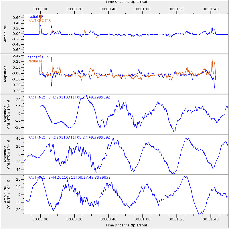
TKM2 KN.TKM2 - Earthquake Result Viewer
*The percent match for this event was below the threshold and hence no stack was calculated.
| Earthquake location: |
Near East Coast Of Honshu, Japan |
| Earthquake latitude/longitude: |
36.2/141.6 |
| Earthquake time(UTC): |
2011/03/11 (070) 08:19:24 GMT |
| Earthquake Depth: |
6.8 km |
| Earthquake Magnitude: |
6.5 MB |
| Earthquake Catalog/Contributor: |
WHDF/NEIC |
|
| Network: |
KN Kyrgyz Seismic Telemetry Network |
| Station: |
TKM2 KN.TKM2 |
| Lat/Lon: |
42.92 N/75.60 E |
| Elevation: |
2020 m |
|
| Distance: |
50.2 deg |
| Az: |
299.092 deg |
| Baz: |
74.283 deg |
| Ray Param: |
$rayparam |
*The percent match for this event was below the threshold and hence was not used in the summary stack. |
|
| Radial Match: |
77.06006 % |
| Radial Bump: |
384 |
| Transverse Match: |
86.090416 % |
| Transverse Bump: |
400 |
| SOD ConfigId: |
356183 |
| Insert Time: |
2011-08-13 08:32:14.175 +0000 |
| GWidth: |
2.5 |
| Max Bumps: |
400 |
| Tol: |
0.001 |
|
Signal To Noise
| Channel | StoN | STA | LTA |
| KN:TKM2: :BHZ:20110311T08:27:49.399989Z | 0.89312667 | 1.3703916E-5 | 1.5343754E-5 |
| KN:TKM2: :BHN:20110311T08:27:49.399989Z | 2.3826952 | 1.9003735E-5 | 7.97573E-6 |
| KN:TKM2: :BHE:20110311T08:27:49.399989Z | 1.1650512 | 1.4813365E-5 | 1.2714776E-5 |
| Arrivals |
| Ps | |
| PpPs | |
| PsPs/PpSs | |


