You are here: Home > Network List > TA - USArray Transportable Network (new EarthScope stations) Stations List
> Station 434A Burnet, TX, USA > Earthquake Result Viewer
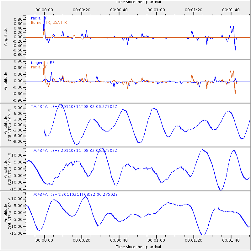
434A Burnet, TX, USA - Earthquake Result Viewer
*The percent match for this event was below the threshold and hence no stack was calculated.
| Earthquake location: |
Near East Coast Of Honshu, Japan |
| Earthquake latitude/longitude: |
36.2/141.6 |
| Earthquake time(UTC): |
2011/03/11 (070) 08:19:24 GMT |
| Earthquake Depth: |
6.8 km |
| Earthquake Magnitude: |
6.5 MB |
| Earthquake Catalog/Contributor: |
WHDF/NEIC |
|
| Network: |
TA USArray Transportable Network (new EarthScope stations) |
| Station: |
434A Burnet, TX, USA |
| Lat/Lon: |
30.81 N/98.27 W |
| Elevation: |
462 m |
|
| Distance: |
92.9 deg |
| Az: |
48.138 deg |
| Baz: |
315.535 deg |
| Ray Param: |
$rayparam |
*The percent match for this event was below the threshold and hence was not used in the summary stack. |
|
| Radial Match: |
63.141926 % |
| Radial Bump: |
400 |
| Transverse Match: |
77.40098 % |
| Transverse Bump: |
219 |
| SOD ConfigId: |
356183 |
| Insert Time: |
2011-08-13 08:59:15.898 +0000 |
| GWidth: |
2.5 |
| Max Bumps: |
400 |
| Tol: |
0.001 |
|
Signal To Noise
| Channel | StoN | STA | LTA |
| TA:434A: :BHZ:20110311T08:32:06.27502Z | 3.5644433 | 1.190218E-5 | 3.3391411E-6 |
| TA:434A: :BHN:20110311T08:32:06.27502Z | 1.3014778 | 7.4217974E-6 | 5.7025923E-6 |
| TA:434A: :BHE:20110311T08:32:06.27502Z | 0.26488608 | 1.7742381E-6 | 6.6981174E-6 |
| Arrivals |
| Ps | |
| PpPs | |
| PsPs/PpSs | |


