You are here: Home > Network List > TA - USArray Transportable Network (new EarthScope stations) Stations List
> Station G36A St. Michael, MN, USA > Earthquake Result Viewer
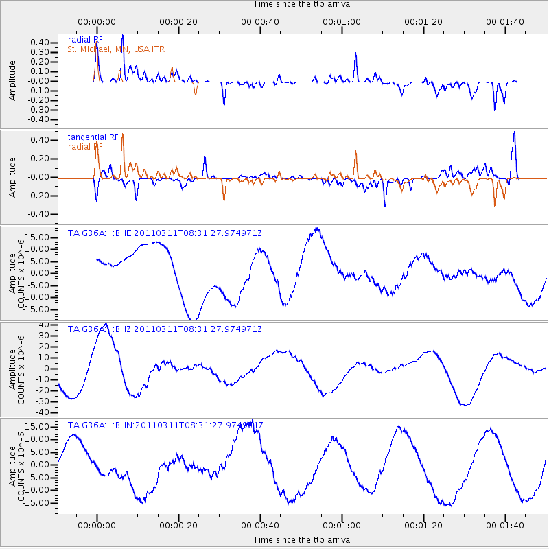
G36A St. Michael, MN, USA - Earthquake Result Viewer
*The percent match for this event was below the threshold and hence no stack was calculated.
| Earthquake location: |
Near East Coast Of Honshu, Japan |
| Earthquake latitude/longitude: |
36.2/141.6 |
| Earthquake time(UTC): |
2011/03/11 (070) 08:19:24 GMT |
| Earthquake Depth: |
6.8 km |
| Earthquake Magnitude: |
6.5 MB |
| Earthquake Catalog/Contributor: |
WHDF/NEIC |
|
| Network: |
TA USArray Transportable Network (new EarthScope stations) |
| Station: |
G36A St. Michael, MN, USA |
| Lat/Lon: |
45.23 N/93.75 W |
| Elevation: |
293 m |
|
| Distance: |
84.8 deg |
| Az: |
35.69 deg |
| Baz: |
318.079 deg |
| Ray Param: |
$rayparam |
*The percent match for this event was below the threshold and hence was not used in the summary stack. |
|
| Radial Match: |
77.075645 % |
| Radial Bump: |
315 |
| Transverse Match: |
60.57292 % |
| Transverse Bump: |
312 |
| SOD ConfigId: |
356183 |
| Insert Time: |
2011-08-13 09:16:42.128 +0000 |
| GWidth: |
2.5 |
| Max Bumps: |
400 |
| Tol: |
0.001 |
|
Signal To Noise
| Channel | StoN | STA | LTA |
| TA:G36A: :BHZ:20110311T08:31:27.974971Z | 3.235095 | 3.4786746E-5 | 1.0752929E-5 |
| TA:G36A: :BHN:20110311T08:31:27.974971Z | 0.7819096 | 4.968292E-6 | 6.354049E-6 |
| TA:G36A: :BHE:20110311T08:31:27.974971Z | 1.3303715 | 1.3387981E-5 | 1.006334E-5 |
| Arrivals |
| Ps | |
| PpPs | |
| PsPs/PpSs | |


