You are here: Home > Network List > AZ - ANZA Regional Network Stations List
> Station LVA2 AZ.LVA2 > Earthquake Result Viewer
LVA2 AZ.LVA2 - Earthquake Result Viewer
| Earthquake location: |
Northern Algeria |
| Earthquake latitude/longitude: |
37.0/3.6 |
| Earthquake time(UTC): |
2003/05/21 (141) 18:44:20 GMT |
| Earthquake Depth: |
12 km |
| Earthquake Magnitude: |
6.5 MB, 6.9 MS, 6.8 MW, 6.7 MW |
| Earthquake Catalog/Contributor: |
WHDF/NEIC |
|
| Network: |
AZ ANZA Regional Network |
| Station: |
LVA2 AZ.LVA2 |
| Lat/Lon: |
33.35 N/116.56 W |
| Elevation: |
1435 m |
|
| Distance: |
90.5 deg |
| Az: |
313.659 deg |
| Baz: |
43.813 deg |
| Ray Param: |
0.041665267 |
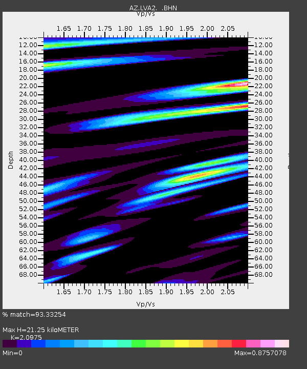
| Estimated Moho Depth: |
21.25 km |
| Estimated Crust Vp/Vs: |
2.10 |
| Assumed Crust Vp: |
6.264 km/s |
| Estimated Crust Vs: |
2.986 km/s |
| Estimated Crust Poisson's Ratio: |
0.35 |
|
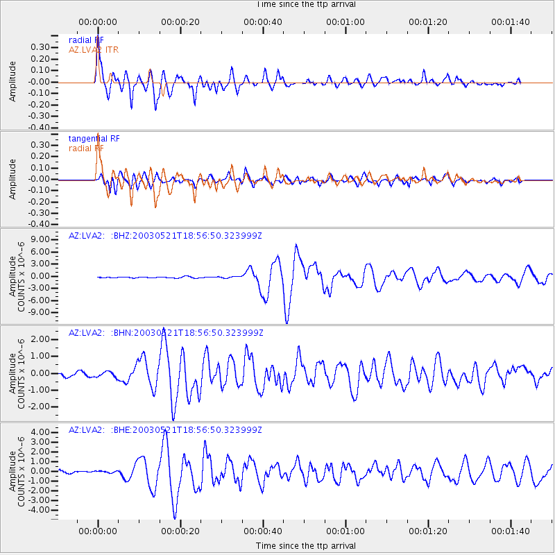
| Radial Match: |
93.33254 % |
| Radial Bump: |
400 |
| Transverse Match: |
83.923195 % |
| Transverse Bump: |
400 |
| SOD ConfigId: |
32974 |
| Insert Time: |
2010-02-26 19:45:27.197 +0000 |
| GWidth: |
2.5 |
| Max Bumps: |
400 |
| Tol: |
0.001 |
|
Signal To Noise
| Channel | StoN | STA | LTA |
| AZ:LVA2: :BHN:20030521T18:56:50.323999Z | 1.3735116 | 1.8630604E-7 | 1.3564214E-7 |
| AZ:LVA2: :BHE:20030521T18:56:50.323999Z | 0.56329244 | 9.951082E-8 | 1.7665924E-7 |
| AZ:LVA2: :BHZ:20030521T18:56:50.323999Z | 1.5318063 | 2.0514183E-7 | 1.3392152E-7 |
| Arrivals |
| Ps | 3.8 SECOND |
| PpPs | 10 SECOND |
| PsPs/PpSs | 14 SECOND |


