You are here: Home > Network List > TA - USArray Transportable Network (new EarthScope stations) Stations List
> Station E36A McGregor, MN, USA > Earthquake Result Viewer
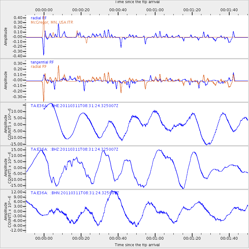
E36A McGregor, MN, USA - Earthquake Result Viewer
*The percent match for this event was below the threshold and hence no stack was calculated.
| Earthquake location: |
Near East Coast Of Honshu, Japan |
| Earthquake latitude/longitude: |
36.2/141.6 |
| Earthquake time(UTC): |
2011/03/11 (070) 08:19:24 GMT |
| Earthquake Depth: |
6.8 km |
| Earthquake Magnitude: |
6.5 MB |
| Earthquake Catalog/Contributor: |
WHDF/NEIC |
|
| Network: |
TA USArray Transportable Network (new EarthScope stations) |
| Station: |
E36A McGregor, MN, USA |
| Lat/Lon: |
46.52 N/93.26 W |
| Elevation: |
393 m |
|
| Distance: |
84.1 deg |
| Az: |
34.571 deg |
| Baz: |
318.325 deg |
| Ray Param: |
$rayparam |
*The percent match for this event was below the threshold and hence was not used in the summary stack. |
|
| Radial Match: |
48.44071 % |
| Radial Bump: |
400 |
| Transverse Match: |
58.99908 % |
| Transverse Bump: |
250 |
| SOD ConfigId: |
356183 |
| Insert Time: |
2011-08-13 09:19:33.736 +0000 |
| GWidth: |
2.5 |
| Max Bumps: |
400 |
| Tol: |
0.001 |
|
Signal To Noise
| Channel | StoN | STA | LTA |
| TA:E36A: :BHZ:20110311T08:31:24.325007Z | 0.80994594 | 1.0490296E-5 | 1.2951847E-5 |
| TA:E36A: :BHN:20110311T08:31:24.325007Z | 0.3684595 | 2.3445912E-6 | 6.363226E-6 |
| TA:E36A: :BHE:20110311T08:31:24.325007Z | 1.1319332 | 1.01222795E-5 | 8.94247E-6 |
| Arrivals |
| Ps | |
| PpPs | |
| PsPs/PpSs | |


