You are here: Home > Network List > TA - USArray Transportable Network (new EarthScope stations) Stations List
> Station L02D Cave Junction, OR, USA > Earthquake Result Viewer
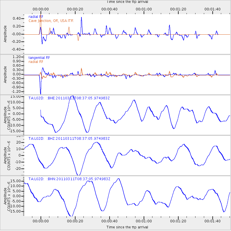
L02D Cave Junction, OR, USA - Earthquake Result Viewer
*The percent match for this event was below the threshold and hence no stack was calculated.
| Earthquake location: |
Off East Coast Of Honshu, Japan |
| Earthquake latitude/longitude: |
37.4/143.0 |
| Earthquake time(UTC): |
2011/03/11 (070) 08:26:36 GMT |
| Earthquake Depth: |
17 km |
| Earthquake Magnitude: |
6.1 MB |
| Earthquake Catalog/Contributor: |
WHDF/NEIC |
|
| Network: |
TA USArray Transportable Network (new EarthScope stations) |
| Station: |
L02D Cave Junction, OR, USA |
| Lat/Lon: |
42.16 N/123.60 W |
| Elevation: |
458 m |
|
| Distance: |
68.3 deg |
| Az: |
53.003 deg |
| Baz: |
301.152 deg |
| Ray Param: |
$rayparam |
*The percent match for this event was below the threshold and hence was not used in the summary stack. |
|
| Radial Match: |
72.2959 % |
| Radial Bump: |
400 |
| Transverse Match: |
71.59558 % |
| Transverse Bump: |
400 |
| SOD ConfigId: |
356183 |
| Insert Time: |
2011-08-13 10:50:44.386 +0000 |
| GWidth: |
2.5 |
| Max Bumps: |
400 |
| Tol: |
0.001 |
|
Signal To Noise
| Channel | StoN | STA | LTA |
| TA:L02D: :BHZ:20110311T08:37:05.974983Z | 2.018556 | 1.6675958E-5 | 8.261331E-6 |
| TA:L02D: :BHN:20110311T08:37:05.974983Z | 0.25575125 | 2.860993E-6 | 1.1186624E-5 |
| TA:L02D: :BHE:20110311T08:37:05.974983Z | 0.88741 | 8.344963E-6 | 9.40373E-6 |
| Arrivals |
| Ps | |
| PpPs | |
| PsPs/PpSs | |


