You are here: Home > Network List > TA - USArray Transportable Network (new EarthScope stations) Stations List
> Station J33A Davis, SD, USA > Earthquake Result Viewer
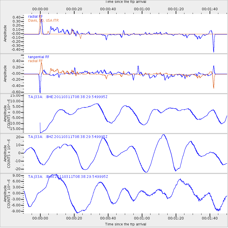
J33A Davis, SD, USA - Earthquake Result Viewer
*The percent match for this event was below the threshold and hence no stack was calculated.
| Earthquake location: |
Off East Coast Of Honshu, Japan |
| Earthquake latitude/longitude: |
37.4/143.0 |
| Earthquake time(UTC): |
2011/03/11 (070) 08:26:36 GMT |
| Earthquake Depth: |
17 km |
| Earthquake Magnitude: |
6.1 MB |
| Earthquake Catalog/Contributor: |
WHDF/NEIC |
|
| Network: |
TA USArray Transportable Network (new EarthScope stations) |
| Station: |
J33A Davis, SD, USA |
| Lat/Lon: |
43.32 N/96.97 W |
| Elevation: |
400 m |
|
| Distance: |
83.0 deg |
| Az: |
39.549 deg |
| Baz: |
315.966 deg |
| Ray Param: |
$rayparam |
*The percent match for this event was below the threshold and hence was not used in the summary stack. |
|
| Radial Match: |
63.77841 % |
| Radial Bump: |
400 |
| Transverse Match: |
55.352024 % |
| Transverse Bump: |
400 |
| SOD ConfigId: |
356183 |
| Insert Time: |
2011-08-13 11:11:00.679 +0000 |
| GWidth: |
2.5 |
| Max Bumps: |
400 |
| Tol: |
0.001 |
|
Signal To Noise
| Channel | StoN | STA | LTA |
| TA:J33A: :BHZ:20110311T08:38:29.549995Z | 2.8374376 | 1.2520893E-5 | 4.4127464E-6 |
| TA:J33A: :BHN:20110311T08:38:29.549995Z | 1.0892261 | 4.914339E-6 | 4.5117713E-6 |
| TA:J33A: :BHE:20110311T08:38:29.549995Z | 1.5078826 | 1.0686221E-5 | 7.086905E-6 |
| Arrivals |
| Ps | |
| PpPs | |
| PsPs/PpSs | |


